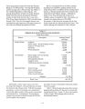
| OCR Text |
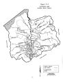
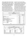
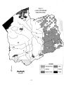
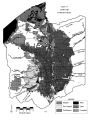
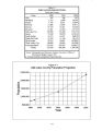
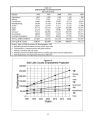
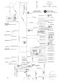
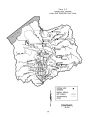
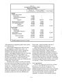
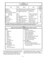
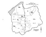
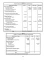
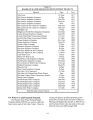
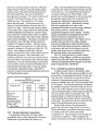
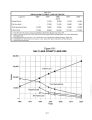
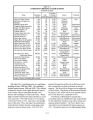
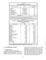
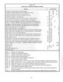
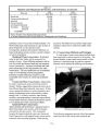
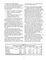
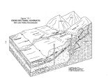
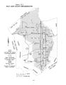
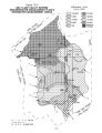
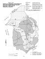
Show - Table 10- 2 IRRIGATED LAND BY CROP Jordan River Basin Crop Type 1994 acres Alfalfa 6,858 Irrigated pasture 9,016 Grain 2,267 Corn 1,705 Grass/ turf 115 Grass/ hay 240 Idle 4,156 Fallow 561 Vegetables 122 Fruits 90 Beans 103 Potatoes 5 Other horticulture 77 Total irrigated acres 25,316 Water- Related Land Use Inventories - Lower Jordan River Area, Utah Division of Water Resources, March 1994, unpublished. 10.3.2 Dry Cropland Over 40 percent of the agricultural ground is dry cropland. The majority of the dry cropland is located above the west side canals in the southwest portion of the valley, primarily the South Jordan and Riverton areas, extending west to Copperton and north to the Kearns and Magna area. As with the irrigated lands, dry croplands are primarily used for the production of feed grains With the ever- growing reduction in irrigated lands and^ the increasing availability of agricultural water, these dry croplands have potential for conversion to irrigated lands, the primary constraint being the pumping cost. 10.4 Agricultural Water Problems and Needs Although agriculture continues to use a significant portion of the total water supply, farms and ranches are steadily being replaced by residential and commercial developments. The resulting loss of irrigated agricultural land is also the driving force currently changing basic water use. Irrigation supplies of high water quality have already been converted to municipal and industrial uses. Although adequate for irrigation, the basin's remaining irrigation supplies are of poor quality. Converting the water to municipal and industrial uses is expected to be quite expensive. Farming, as an occupation, has undergone fundamental changes in recent years. This has resulted in many farmers leaving, or relying on off- farm employment to supplement their incomes. On the whole, however, these changes are a result of national and international political and economic restructuring. 10.4.1 Irrigation Water Water is diverted from the Jordan River to the east and west sides of the valley through a series of parallel canals. The west side of the valley is served primarily by a system of four canals. From the uppermost to the lowest these are Welby Canal ( starting at elevation 4700), Utah Lake Distributing Canal ( 4575), Utah and Salt Lake Canal ( 4480), and the South Jordan Canal ( 4425). The east side of the valley is primarily served by a system of three parallel canals: Draper Irrigation Company Canal ( starting at elevation 4560), East Jordan Canal ( elevation 4480), and Jordan and Salt Lake Canal ( 4425). See Figure 3- 2 for canal locations. These parallel distribution systems are very complex with numerous inter- canal exchanges. Such a system allows for efficient use of water since surface water runoff from higher agricultural areas can be collected and distributed by lower canals. Virtually all of the surface water supplies used for agriculture come from the Jordan River. The cost of treating Jordan River/ Utah Lake water to drinking water standards is currently prohibitive. Consequently, the quantity and quality of water available for agriculture is not a problem. With large tracts of formerly irrigated lands now converted to residential developments, there is more than enough water available for the lands remaining in agricultural production. The average annual diversion for irrigated cropland is 143,000 acre- feet. In 1995, an estimated 126,000 acre- feet of water was diverted to irrigate about 25,300 acres of cropland. 10.4.2 Erosion Watershed management is the protection, conservation and use of all the natural resources of a watershed in such a way as to keep the soil mantle in place and productive. It also assures water yield and water quality meet the existing and potential uses. If not properly protected, watershed lands are readily damaged from erosion, floods, sediment and fire. In the Jordan River Basin, however, the primary concern with erosion is one of water quality. With the rapid conversion of agricultural lands to residential and commercial uses, the preservation of 10- 4 |