| OCR Text |
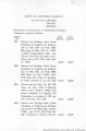
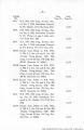
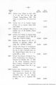
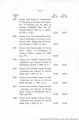
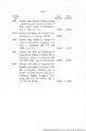
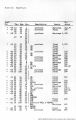
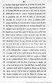
Show D-10 (b) (Cont«d.): Range 23 West, Yuma County for irrigation purposes. Water Appropriation dated February, 1914 and recorded March 9, 1914 in Book 1, page 8, Water Appropriations by Barok L. Hoge for 5,000 miners inches flow of unappropriated waters of Colorado River water at this point at the north end of Paradise Valley near Light House Rock and about eight miles above Hoge Ferry in Township 4 South, Range 24 West, Yuma County for irrigation purposes. Notice of Appropriation of water dated March 25, 1915 and recorded May 27, 1915 in Book 1, page 17, Water Appropriations, by H. E. Linden for 50,000 cubic feet per second of Colorado River water both surface and underflow. Notice posted on bank of Colorado River approximately 19,#00 feet north east of Town of Parker, Arizona and appropriated for irrigation and other beneficial uses. Notice of Water Appropriation dated February 15, 1916 and recorded April 20, 1916 in Book 1, page 24, Water Appropriations, by New La Paz Gold Mining Co., by 0. L. Grimsley, President and General Appropriator for 10,000,000 miners inches measured under four inch pressure of water flowing in the underground stream and lying in the underground river bed of the Colorado River bottom, County of Yuma, State of Arizona. This notice is posted at a point in the southeast corner of Section 19, Township 4, the north boundary of this claim is the south boundary of the Colorado River Indian Reservation. |
| Source |
Original book: [State of Arizona, complainant v. State of California, Palo Verde Irrigation District, Coachella Valley County Water District, Metropolitan Water District of Southern California, City of Los Angeles, California, City of San Diego, California, and County of San Diego, California, defendants, United States of America, State of Nevada, State of New Mexico, State of Utah, interveners] : California exhibits. |