Contents | 60 of 457


page 7


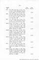
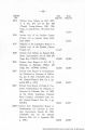
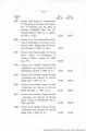
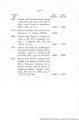
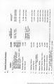
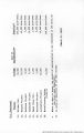
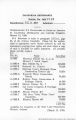
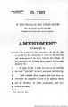
| Title | AZ vs. CA:13 California Exhibits, Vol. XIII; Nos. 1800-1842; 1901-1906; 2000-2044 |
| Creator | Arizona, complainant.; California, ; defendant.; Palo Verde Irrigation District (Calif.), ; defendant.; United States.; Supreme Court. |
| Subject | Water rights; Water consumption; Rivers |
| Date | 1958 |
| Type | Text |
| Format | application/pdf |
| Language | eng |
| Rights Management | Digital Image Copyright 2005, University of Utah. All Rights Reserved. |
| Holding Institution | 5th Special Coll. Rare, University Library, California State University, Long Beach |
| Source Physical Dimensions | 25 v. : ill. (some folded) ; 25 cm. |
| Scanning Contractor | Backstage Library Works - 1180 S. 800 E. Orem, UT 84097. |
| ARK | ark:/87278/s6th8kkt |
| Setname | wwdl_azvca |
| ID | 1125838 |
| Reference URL | https://collections.lib.utah.edu/ark:/87278/s6th8kkt |
Page Metadata
| Title | page 7 |
| Format | application/pdf |
| Source | Original book: [State of Arizona, complainant v. State of California, Palo Verde Irrigation District, Coachella Valley County Water District, Metropolitan Water District of Southern California, City of Los Angeles, California, City of San Diego, California, and County of San Diego, California, defendants, United States of America, State of Nevada, State of New Mexico, State of Utah, interveners] : California exhibits. |
| Resource Identifier | 130100-UUM-AvC-v13t1815_page 7.jpg |
| Setname | wwdl_azvca |
| ID | 1125440 |
| Reference URL | https://collections.lib.utah.edu/ark:/87278/s6th8kkt/1125440 |