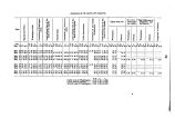
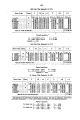
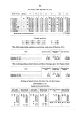
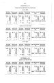
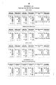
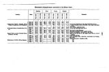
| OCR Text |
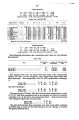
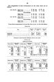
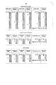
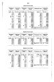
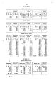
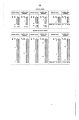
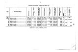
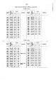
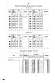
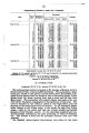
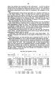
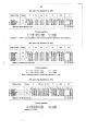
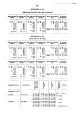
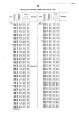
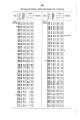
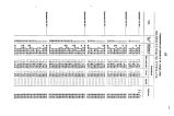
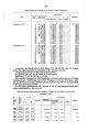
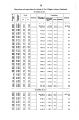
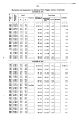
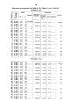
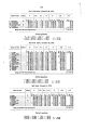
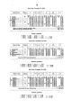
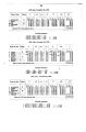
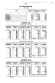
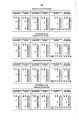
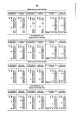
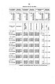
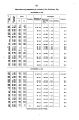
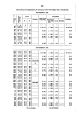
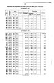
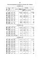
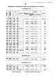
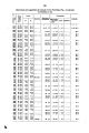
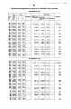
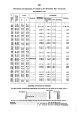
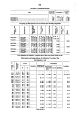
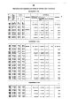
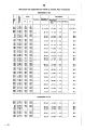
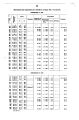
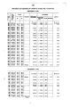
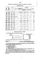
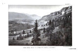
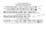
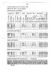
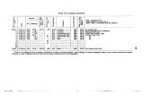
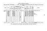
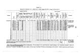
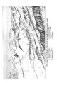
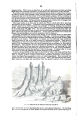
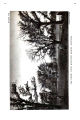
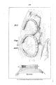
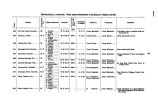
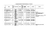
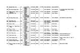
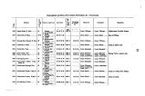
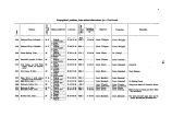
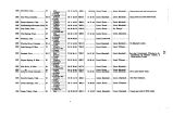
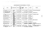
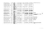
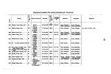
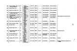
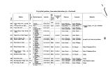
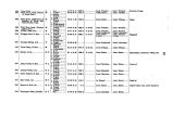
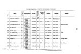
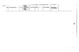
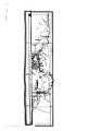
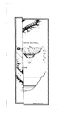
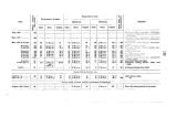
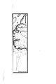
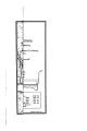
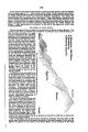
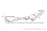
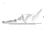
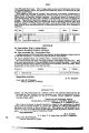
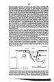
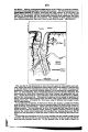
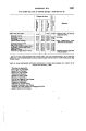
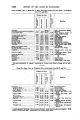
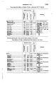
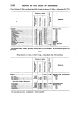
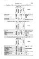
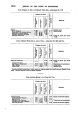
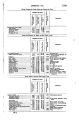
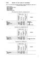
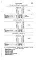
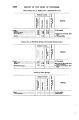
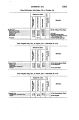
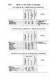
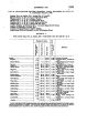
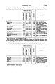
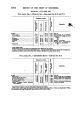
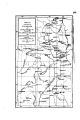
Show APPENDIX NN. 1283 done, and camped at Frank town, in Washoe Valley. November 9, we reached the rendezvous- camp at Carson, where Messrs. Henshawand Cookliug were detached from the party nnder orders received fnrn you early in the Beason. We then passed up the Carsou Valley as far as Genoa Hot Springs, connectiug with work previously done. Upon the completion of thU we proceeded to oconp. v a peak iu the range of mountains east of Carsou Valley, and known to us as Mount Coma. This is a high point almost due south of the peak, in the same range occupied by Lieuteuant Birnie's party early in the reason under the name of Mouut Lyons. On the way to our peak a meander was obtained of Eldorado Cafion, the general course of which is nearly north and south, its mouth being near Dayton on the Carson River. Soft gray limestone occurs near the eufcrauce quite plentifully, and is burned in a lime- kiln at this point. A good toll- road runs up this ca& ou, and a small stream meanders its way through it, crossing the road at frequent iutervals. The slopes ou nither hide are bare of vegetation, except now and then a little sage or a scrubby pine. The lack of vegetation allows one to see easily the fantastic shapes into which the elements have carved the rocky sides, but the heat in summer must be very great. Near the head of this canon is situated the Virgiuia City Company's coal- mine, the product being a lignite of fair quality. Proceeding onward some 3 miles from the mine we camped near the base of what is locally named Mineral Hill, where lie the springs in which Eldorado Creek rises. This hill stands up well when vjewed from the neighborhood of Virgiuia City, and was observed, I believe, by the party there nnder the name of Co mo. The point known to us uuder this name, however, lies some four miles o the southeast, and is considerably higher, being in the m tin ran^ e, which runs nearly tnorth and south, and is called in the neighborhood the " Como Range," after an abandoned mining- town of that name uear M mut Lyons. It has also been frequently called the Pine Nut Range, after the timber of that name, which was once quite plentiful, but which has now been almost entirely cut off for fuel. About 28 miles in leugth, it breaks down on the north into the valley of the Carsoa River, which sweeps round that end, and on the sonth into that of the West Walker. About 4 miles north of us the ridge sends out a spur, to the eastward, which drains to the north into the Carson, and on the sonth ioto the West Walker. Just to the east lies a barren, sandy valley containing a small alkaline fiat. To the east of this is a range of low, sandy hills, beyond which lies Mason's Valley, through which flows the main stream of the Walker River. The eastern slope is quite steep, while the western falls gradually off to the Carson Valley, being broken up into valleys and canons by minor ranges and foot- hills. Mineral Hill is high enough to hide the Carson Valley to the northeast, but it is visible for nearly its whole length sonth of Genoa. Finishing our work here we returned to Carsou by way of the Bruuswick Can on, through which runs a fair wagon- road, which crosses the cafi6* h by a bridge at the Brunswick Mill, where there is a toll- bouse. Leaving Carson again, the quartz- mills along the river between Empire and Dayton were located; ihen passing through Virginia City the survey of the Geiger Grade, leading thence into Steamboat Valley, was taken np where the work of Lieutenant Sytuons's party ceased, aud camp was made at Steamboat Springs, on the Virginia and Truckee Railroad. These springs are among the most interesting iu the State, and have been known for many years. Clonus of vapor continually rising make them conspicuous for several miles. From the name one might be led to expect that the emission of this vapor would be accompanied by a sound like that made by the exhanst- steam of a western river steamer, but I noticed nothing of the sort. Tne rocky mound in which the springs lie is situated at the base of a spur of Mount Rose. Numerous small pools are fouud on the snmmit of this mound, the temperature of the water varying from blood- beat to almost boiling. Besides the pools, loug irregular fissures occur from a few inches to a foot in width, and extending to a considerable depth. In these the water can be seen boiling aud bubbling violently, sometimes disappearing entirely, then rising to view again. In some of the pools I noticed a white deposit like that frequently seen in sulphur springs. The water when cool is perfectly drinkable, and is not BO impregnated with minerals as to prevent the use of soap iu washing. A hotel has been erected here aud has connected with it a commodious batb- bous? » , which is built directly over some of the fissures above referred to. The springs are easy of ac- • cess, being by rail only 11 miles from Reno on the Central Pacific Railroad, and about 20 from Caason. They are considerably resorted to during the summer on account of the medicinal properties of their waters.' Steamboat Creek flows a few hundred feet east of the springs and empties iuto the Truckee. Steamboat Valley contains a considerable amount of arable and grazing land, and widens out on the north into the Truckee meadows. Our next camp was at Glendale, a small hamlet on theTrnckee, and formerly a station on the old transcontinental emigraut- road. Passing from here np the east side of Steamboat Valley along the base of the range running north from Mount Davidson several topographical stations were made on the ridge, and a small portion of the shore |