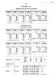
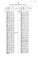
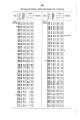
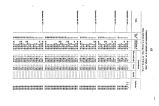
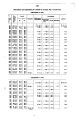
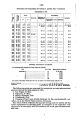
| OCR Text |
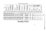
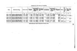
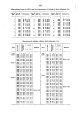
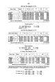
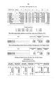
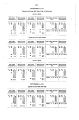
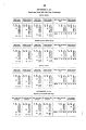
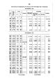
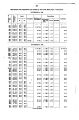
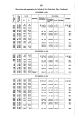
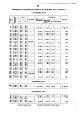
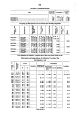
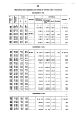
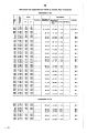
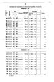
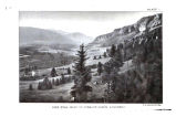
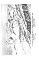
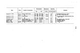
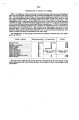
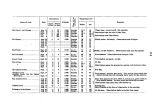
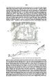
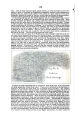
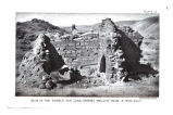
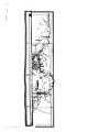
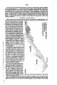
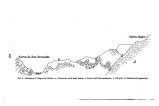
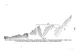
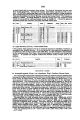
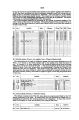
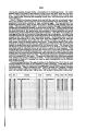
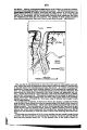
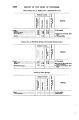
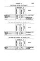
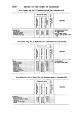
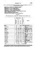
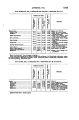
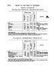
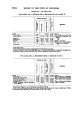
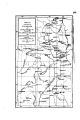
Show APPENDIX HN. 1267 Banch. From this place he made a trip to Poston Peak, at the headwaters of Reese River. In this range, from Prometheus to Poston, a distance of 48 miles, six prominent peaks were occupied. Severe weather was encountered by that party, with snow- storms and cold. Especially on Poston Peak the party suffered severely; there Mr. Spiller had both ears badly frozen. This work occupied twenty days. In the mean time the party moved up Reese River Valley. The road from Austin to lone was meandered throughout. From Elkhoro the pack- train went to Washington, in the Toy a be foot- hills, to resupply Mr. Spiller's party. With Mr. Cowles, I made a trip of six days into the Shoshone Mou ntains. We recro* sed the valley to Washington, and then proceeded to McMahon's, to rendezvous with the other party. In the Shoshone Range, from Mount Airy south to lone Pass, a distance of 40 miles/ seven prominent points on the main divide were occupied. The party was now ready to move westward, through the southern portion of our area, with the object in view to complete the survey of the area iu a north and south direction as we moved. At our cainp ut McMahon's we separated as usual, the next rendezvous being appointed at Ellsworth. Mr. Spiller, Private Niver, and myself formed one party. Our route led us a second time to lone. This is a miuing- town on the western slope of the Shoshone Mountains, a little tooth of latitude 39° 30'. The mines have been opened for some y « ars, and promised well when first opened. For several years back little work has been done in thein. New capital at this time was awakening the place to a good deal of activity. The same may be said of the town of Ellsworth, across the valley to the west; here, however, new discoveries were also being made. From lone we crossed the lone Valley in a southwesterly direction, to Antelope Springs, in the Mammoth Mountains. This valley is but an extension south of the Smith's Creek Valley, the divide between thein being very low. The Mammoth Range, here so called, is but an extension of the Desatoya Range. Paradise and Park Peaks, south of Ellsworth, were occupied. The range is not high, but there i s an abundance of wood and a number of springs. lone Valley, east of it, is without water; but it drains well to the south, and gives some pasturage iustead'of barren flats. To the west the range falls abruptly to barren foot- hills and the Hi> t Springs Valley with its alkaline flat. The difference of level between lone Valley and Hot Springs Valley is about 2,000 feet, the same as observed to the north between Smith's Creek Valley and Fairview Valley.. The same range forms the dividing line, but on the west the two valleys do not run into each other, as do Smith's Creek and lone, but a considerable range of hills running east and west separate Hot Springs and Fairview Valleys. This Mammoth Range is a very distinct line of demarkation between the country to its west at d that to the east between latitude 38° 40* and 39° 30'. The type of country westward extends as far as Mason Valley, and to the Como Range. The Carson River, in its lower part, struggles through it. Apparently fiuding itself baffled in its westerly course, the desert turns off to the north, to absorb the wa'ers of the Humboldt and Truckee Rivers. The type is a country whose valleys are alkaline flats, and whose mountains are low, igneous hills, without wood aud with very little water. From McMahon's the remainder of the party had returned aloug the Reese River Valley aud crossed the Shoshone Range to Petersen's Ranch, in 8mith's Creek Valley, and thence proceeded south through lone Valley to Ellsworth. Ellsworth is t- everal miles from the summit of the range, and on the eastern slope. The first mines were worked about the site of the town. The impetus now at work is derived from mines on the western or exposed slope of the range. A new town, called Summit City, is being built at the summit, and near these mines. At present water must be hauled there, bnt it can be brought in pipes from a spring at no great distance. From Ellsworth, Chalk Well was revisited, to complete the survey of the freight-road from West Gate. Our next camp after Ellsworth was at Welsh's Spring, near the mouth of Marble Falls Canon, and at the base of the bluffs on the west side of the range. It is but 5£ miles from Ellsworth. About 3£ miles across the small valley, west of this spring, is the Illinois mine, the principal one of the new mining district of Lodi. At Ellsworth, I engaged an Indian guide to take a small party through the very dry country lying between West Gate aud Hot Springs Valley. Mr. Spiller, the guide, one packer, and myself composed the party. The rest of the party moved southwesterly to Hot Springs Valley, and camped there at some cold- water springs, where they also found some grass for the animals, but were badly off for wood. Our small party was out four days. The first day, after having occupied the highest point in the hills just west of the Illinois mine, we marched northwest about 9 miles, and camped high up on the rocky slopes of a low peak that was occupied as a station the following day. At this camp the water was in a hole, under and inclosed in the solid rook, and besides being scarce was very difficult to obtain. The guide gave us to understand, however, that in the spring we would find there plenty ot water. The wood there was very scant sage- brush. Our second camp was at a spring 7 miles west of this; this spriug is hidden in a flat |