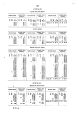
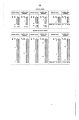
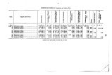
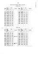
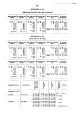
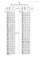
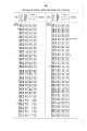
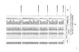
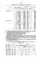
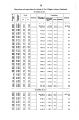
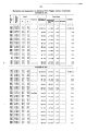
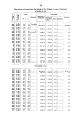
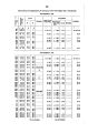
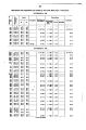
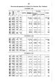
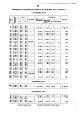
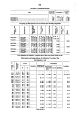
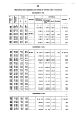
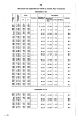
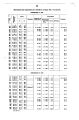
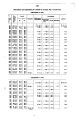
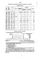
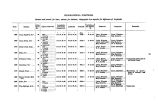
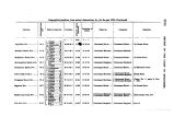
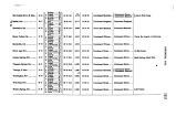
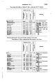
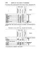
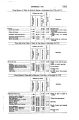
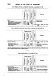
| OCR Text |
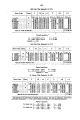
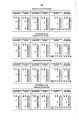
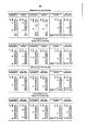
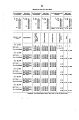
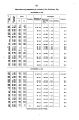
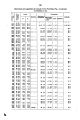
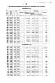
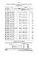
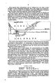
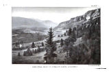
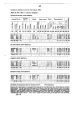
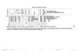
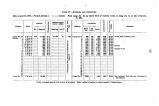
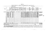
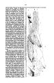
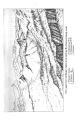
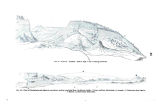
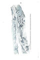
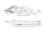
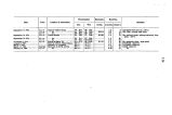
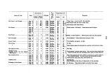
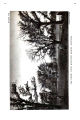
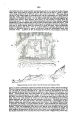
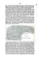
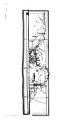
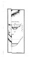
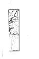
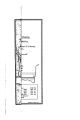
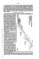
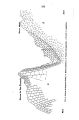
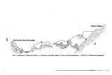
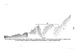
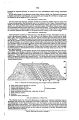
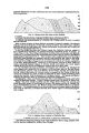
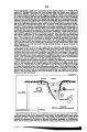
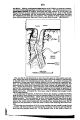
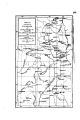
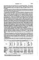
Show 132 hot in summer. Hot springs are found at nearly the lowest point, which is on the east side of the valley, at the base of the Panamint range. A valuable salt marsh is near them. The mining- town is situated near the summit of the range, in a cation of the same name, ( Panamint,) and is reached from Panamint Valley by a very steep but excellent wagon- road. ( Dr. Loew also visited this place for report.) While at this camp, all our animals, except a few required for short trips, were sent a distance of about 30 miles, where pasture could be obtained; we were thus enabled to recruit materially those that had developed signs of weakness. From this place, with a portion of the party, I crossed the head of the carion in which the town is situated, and from the summit of the pass we Overlooked Death Valley and the Amargosa range beyond on the east and Panamint Valley on the went. The first portion of the descent to Death Valley by trail was* very steep. In the caftou through which we passed grass and a short running stream were found, also a small cultivated piece of ground, where vegetables were raised with facility by irrigation. Entering Death Valley, wetwnied northward and ramped two days at Bennett'a Well* nearly on the edge of the great alkaline deposit of the valley; but permanent*, and very good water, only a little alkaline, was found in the wells- three or four holes scarcely more than 6 feet deep- while a coarse green bunched grass furnished pasture for the animals and mesquite trees grew sparsely around. Our barometric observations show this camp to have been within a few feet of the sea- level, ( below.) Two trips were made to determine the lowest point of the valley. On the first day, moving out into the valley nearly in an easterly direction, I was induced to turn northward from the washes met with, showing a flow of water had been in that direction. I believe, however, the slight difference of level throughout allowed the water ( in the wet season) to be driven by the prevailing winds from the south, and at least greatly assisted in the formation of these channels. This valley on the south receives the flow of the Amargosa, and on the north that of Furnace Creek and of the more northern and higher portions of the valley, with much of the drainage of the Panamint and Amargosa ranges. Water collects in these drains only in the wet season, xhe southern and nearly flat portion of the valley seems to extend north and south for 20 to 30 raileB. From what I could observe, I am incliued to think there are two low portions situated on either side of the center of this flat portion. Two trips across the valley, made after th\ B first, the one to the south and the other to the north, showed a less elevation. It is to be remarked, however, that our first and central trip was not entirely across the valley, as in the other cases, but was far enough to support the opinion expressed. The second day we crossed the valley to the south of the first line, and, as before remarked, our observations showed a greater depression, which was near the eastern edge. In this vicinity, where water had evidently stood not long before, the surface was an unbroken crust of salt, probably an inch thick; the appearance of a beach and - water- waves was thoroughly impressed upon the white surface of the salt as the water dried up, and the effect was very fine. Even at'this time, nearly the driest season of the year, great difficulty was experienced in traveling about the valley; the marshy, soft ground in one place, ana the dry honey- combed loose surface in another, made traveling with animals exceedingly dangerous, while again the ground was smooth and baked hard enough to readily support them. On both these days we were compelled to leave our animals and make the rest of our journey on foot, sometimes sinking nearly to the knees in ash- colored mud beneath the salt. This flat portion of the valley is about 5 miles wide, ( opposite Bennett's Wells,) and while the lowest point may not have been discovered, enough has been developed to show that there is a large tract nearly flat, and a great portion of tins approaching 100 feet depression from the sea- level. I may here remark that probably the only way to thoroughly solve this problem would be to run several instrumental level- lines through the length of the valley, and this would be almost impracticable from the marshy character of the ground; many places are, I am sure, impassable. Two fresh- water springs are found on the western edge of the flat north of the wells, but the waters of both seem somewhat medicinal, and are said to be unwholesome. We did not suffer as much from the heat as had been anticipated, although the thermometer was noted atone time at 145° F. in the sun; yet, as at this camp we could receive all the benefit of the breeze from the south, which blew a great portion of the time, the oppressiveness of the heat was obviated, except when there came, as at intervals, blasts of hot air. It is claimed by intelligent persons who have visited the valley that water remains in a body in portions of the flat throughout the year. I was unable to discover any suoh body of water. ( 1 September, 1875.) From Bennett's Wells we moved northwardly along the western border, and crossed to the northeast, over the old emigrant road to Furnace Creek, ( noting a second portion at Salt Springs lower than on the central trip,) where we awaited the arrival of the rest of the party thathad separated from us at CaGon Station, and had moved along the west- |