| OCR Text |
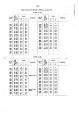
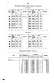
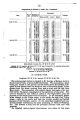
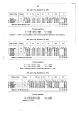
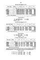
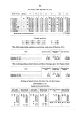
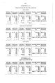
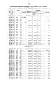
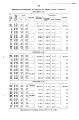
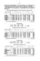
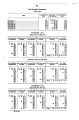
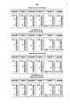
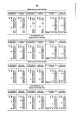
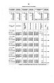
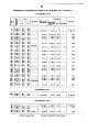
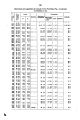
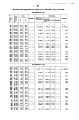
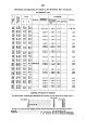
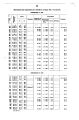
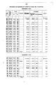
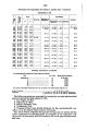
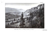
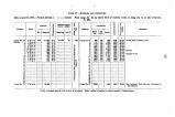
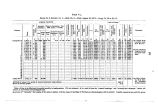
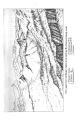
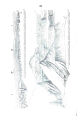
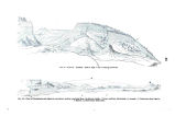
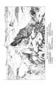
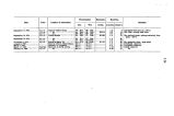
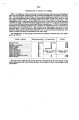
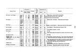
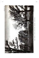
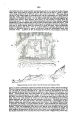
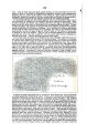
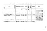
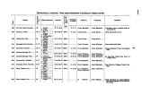
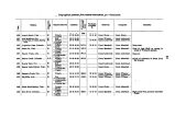
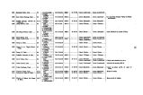
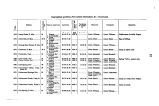
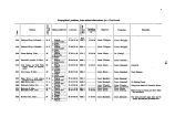
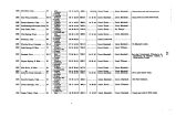
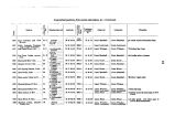
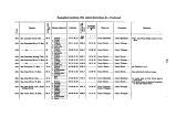
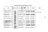
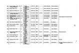
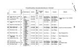
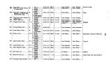
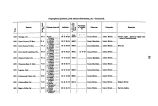
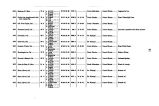
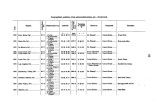
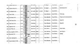
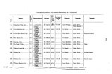
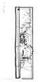
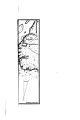
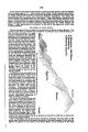
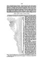
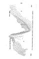
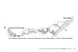
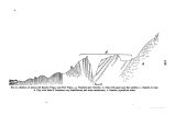
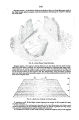
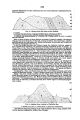
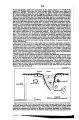
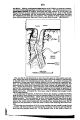
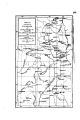
Show APPENDIX NN. 1253 APPENDIX B. EXECUTIVE AND DK8CRIPTTVE REPORT OF LIEUTENANT 8AML. E. TILLMAN, CORPS OP ENGINEERS, ON THE OPERATIONS OF PARTY NO. 1, CALIFORNIA SECTION, FIELD SEASON OF 1876. UNITED STATES ENGINEER OFFICE, GEOGRAPHICAL SURVEYS WEST OF THE 100TH MERIDIAN, Washington, D. C, April 15, 1* 77. SIR: I have the honor to submit the following report upon the country visited by, and the operations of, Party I, California Division, of the expedition for surveys west of the one hundredth meridian during the field season of 1876. The area for work assigned by yourself to Party I falls in atlas- sheet 47, subdivisions " B " and " D" of the progress map, and is between the meridians distant from Greenwich 119° 48' and 120° 3 ^ , and the parallels of 39° 18' and 40° 16'. It is situated immediately north of the portion of the Central Pacific Railroad between the stations of Reno on the east and Cisco on the west. The country to be traversed lay principally in the uplifted region which constitutes the Sierra Nevada Mountains. These uiouutains are here of considerable breadth, and at first sight give the impression of a confused mass, but a little observation shows that they are composed of nearly parallel ridges, the longer ones having to the northward a direction of about 25° west of north. The summit- line of the range is tortuous, correctly located, however, by the direction of drainage. To the east of this line the waters flow to the lakes and sinks of the Nevada basin. To the west they go to the Sacrament') River, thence to the Pacific. The eastern wall of the Sierras crosses the Central Pacific Railroad at about the one hundred and twentieth meridian, which is here the boundary- line between California and Nevada. A single spur of the rauge projects to the east of this meridian and lies in Nevada. About 25 miles west of the eastern wall arises the seooud marked ridge of the Sierras, extending nearly parallel to the eastern, and forming here the western limit of our work. The summit- lines of these ridges have received the local designation of eastern and western summits. The Central Pacific Railroad crosses the true summit- line of the Sierras upon the second of these ridges at about the meridian of 120° 20'. The summit- line, bearing as stated, remains upon this ridge for about 18 miles. It then makes nearly a right angle and crosses to the eastern wall of the Sierras. From this point, latitude 39° 36', it runs nearly due north to parallel 39° 55'. It then has a direction nearly northwest to parallel 40° 16', which was the most northern point visited by me. The axis of the second ridge changes direction at the point at which the summit- line leaves it, latitude 39° 29', bearing nearly due north to parallel 39° 47'. At this parallel is found a second transverse ridge, immediately north of which the longitudinal ridges rise in closer proximity, all having the same trend as the eastern wall. For convenience of description, I have divided the area of my work, situated in the Sierras, into three sections, suggested by the configuration above noted. The southern section is the portion between the Central Pacific Railroad and the transverse divide npon which the summit- line crosses from west to east, and limited on the east and west by the two axial ridges before mentioned. The middle section lies between the same two axial ridges, north of the first and south of the second transverse divides. The northern section is north of the second transverse divide, extending west to meridian 120° 38' and bouuded upon the north and east by the summit- ridge of the Sierras, which here runs nearly northwest. In addition to the mountain area above located, Party I covered a narrow slip along the eastern base of the mountains extending from Reno to the parallel 40° 16'. Of the sections, already indicated, the southern is heavily timbered with pine and broken by long, broad, sloping spurs, usually from the west. The valleys or flats are of small extent and bear the names of the claimants. The waters of this section flow to the Nevada basin, passing the east wall of the mountains by the cafion of the Truckee River. Trnckee and Boca are stations of the Central Pacific Railroad, situated in this section. There are several saw- mills from which lumber is carried to the railroad by flumes. These flumes are V- shaped troughs, supported upon trestle-work, extending from a lower to a higher level. At the higher level a stream of water i s turafod into the trough. This artificial channel then becomes the mea. is for sending down enormous quantities of wood and lumber. Prosser Creek, in this section, has been dammed at the mouth and a poud formed, from which large quantities of ice are procured? Small herds of cattle and sheep are grazed in the flats during Bummer, but descend to lower altitudes in winter. There are but few permanent settlers in this section away from the railroad and the mills. At the western side of this section, close on to the base of the second ridge, are nestled three beautiful bodies of water- Donner, Webber, and Independence Lakes. Donner Lake, the lowest of these, is about 5,800 feet above the sea ; Independence Lake affords excellent fish. The middle section of my work is bounded by the two axial and two transverse ridges previously mentioned. It comprises an elevated valley of considerable extent, called Sierra Valley. This valley would approach in figure. |