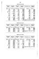
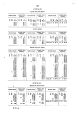
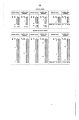
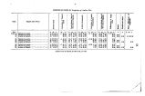
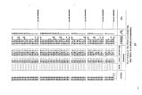
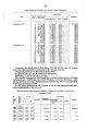
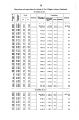
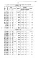
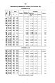
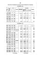
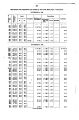
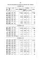
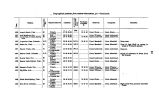
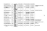
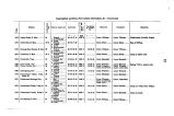
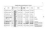
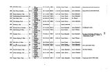
| OCR Text |
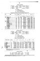
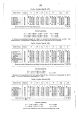
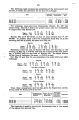
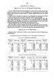
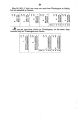
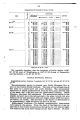
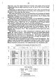
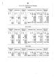
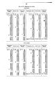
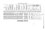
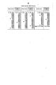
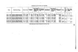
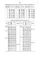
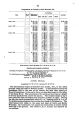
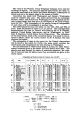
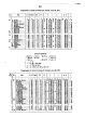
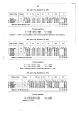
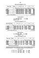
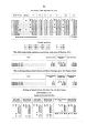
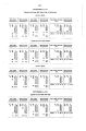
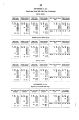
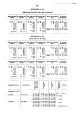
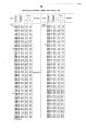
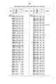
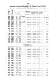
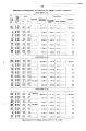
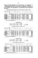
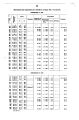
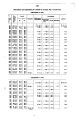
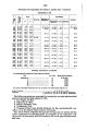
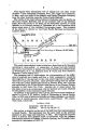
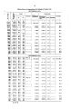
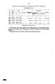
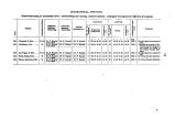
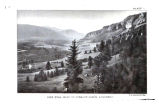
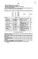
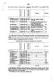
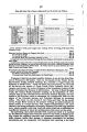
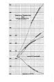
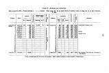
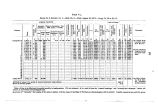
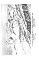
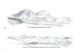
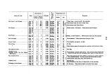
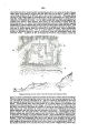
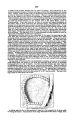
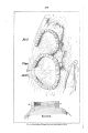
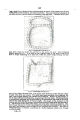
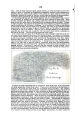
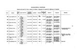
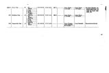
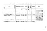
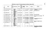
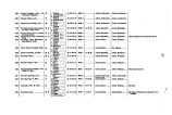
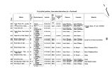
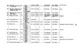
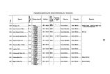
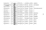
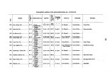
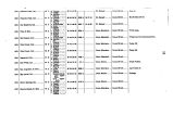
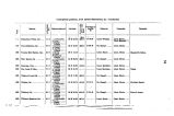
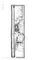
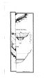
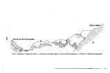
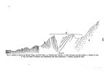
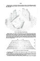
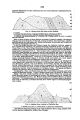
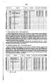
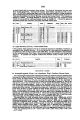
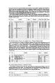
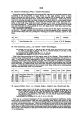
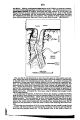
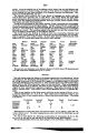
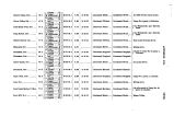
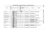
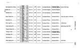
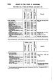
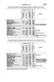
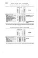
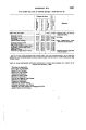
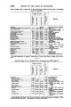
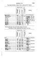
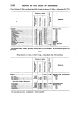
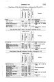
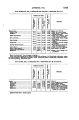
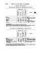
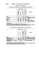
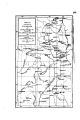
Show 9 point at Georgetown ; thence to proceed by the shortest road to Pike's Peak, which point had been located from a base measured near the astronomical station at Colorado Springs by Dr Kampf, making secondary stations en route ; theuce via the southern rim of South Park and the Platte and Arkansas divide to South Arkansas Creek, and thence to Fort Garland, making the necessary stations to give a connected system of triangles from the northern to the southern limit of our survey, from which points those occupied by Messrs. Young and Schroeder could be fixed. These orders were carried out by Mr. Nell, except that he was prevented by snow from actually occupying one of the main stations near the head of the South Arkansas, suggested to him. This point, though quite accurately fixed in longitude and latitude, must be occupied the coming season. From September 5 to October 10 two parties were continuously employed in completing the survey of the drainage- areas of the upper Arkansas, and that part of the area drained by the Gunnison River which lies east of the one hundred and seventh meridian. From the 10th of October to November 4 a line- survey was run up the valley of the Rio Grande River to the San Juan mining district, but snow, which fell to the depth of 13 inches on the loth, 16th, and 17th of October, prevented any further work in this region at high altitudes and effectually prevented any main stations on mountain- peaks. The Las Animas River w » vS headed, and a line run down this stream connecting with Mr. Nell's trail from Fort Wingate, thence via the Pagosa Hot Springs, Tierra Amarilla, and the head of the east branch of the Chaina, and the San Antonio River to Fort Garland. The streams tributary to the Rio Grande from the west and its main South Fork had meanwhile been meandered by a small party. The Sangre de Christo range south of Fort Garland as far as the New Mexican line was also surveyed by Mr. Young. The interval from November 4 to November 14 was employed by Mr. Nell in measuring a base near Fort Garland and expanding it to his triangulation- stations. A small party uuder the direction of Dr. Rothrock was dispatched on November 9 to Denver via Wet Mountain Valley, the Hardscrable Mines at Rosita, the Coal Mines at Canon City, Colorado Springs, aud mouth of Platte Canon, to define the limits of the foot- hills and meander certain roads and streams. This party arrived at Denver December 4th, 1873. The measurement of the base aud the local triangulatiou about Fort Garland having been completed, the escort returned to its statiou and the supernumerary employes were discharged. My party left Fort Garland November 14, and proceeded, via the Aheyta Pass, to the east of the Sangre de Cristo range, headed the Cucharas, the Apishpa, the Purgatoire, and the North Fork of the Canadian River, made a triangulatiou station upon the Greenhorn Mountain; then proceeded via Mace's Hole, Red Creek, Canon City, Oil Creek, the Canon of the South Platte, North Fork of the South Platte, and Turkey Creek, to Denver, making the necessary topographical stations en route, and, with the lines already run by Messrs. Nell and Young, completing the survey of the foot hills. Ou the 10th day of December the parties were disbanded at Denver, Colorado. METHODS OF SURVEY. The two peaks, Gray's aud Pike's, were located from the astronomical stations at Georgetown aud Colorado Springs, C. T., and the computed length and azimuth of the line connecting them were used as a base for oar triangnlation. |