OCR Text |
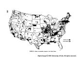
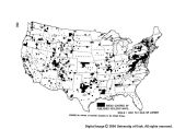
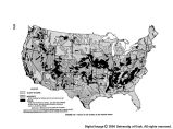
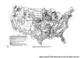
Show Geologic maps are prime requisites for investigations of mineral resources, underground waters, construction materials, and foundations for engineering structure. Since water control structures of all kinds, such as dams, levees, tunnels, and canals, are built on or under the surface of the earth, the determination, interpretation, and application of geologic facts cannot be safely or economi- cally avoided. The planning, designing, or building of such structures requires knowledge as to the strength, durability, water-tightness, and ease of excavation of the geologic materials that underlie them. Highways, like dams and levees, are built both on, and of, geologic materials. Plans for them must include accurate esti- mates, not only of the amount of cut and fill required, whether or not they will tend to slide after every rain, and whether or not the material removed from cuts will stand up when used as fill or for subgrade. Agricultural development, whether by irrigation, drainage, or other means, as well as the classification of lands for these pur- poses, requires knowledge of the permeability of the soils and rocks beneath them, and of the chemical nature of these materials. Status of Geologic Mapping As shown on figure 33, approximately one-tenth of the United States has been mapped geologically on scales of 1 inch equals 1 mile, or larger. One mile to the inch is considered to be the minimum usable scale for any but the broadest kind of planning purposes. Small scale geologic maps (8 miles to the inch or smaller), useful for broad generalizations but for little else, are available for most States. But of these maps, some were compiled years ago and do not include the results of subsequent detailed geologic mapping, and eight States-Maine, North Carolina, Florida, North and South Dakota, Ne- braska, Nevada, and Oregon-do not have even this kind of coverage. Consequently, for any given proposal for water resources development, geologic maps on adequate scales are rarely available. To make matters even worse, large numbers of existing geologic maps have been pre- pared for some special purpose, such as the discovery and delineation of mineral resources. Hence, they tend to stress selected geologic data, such as the character and structures of the rocks at depth, rather than data on rocks closer to the surface, those on which man must live and build. Too, the minerally rich areas that have been mapped seldom coincide with the areas of greatest interest for water and land resource development. The foregoing analysis is based on the scale of mapping as the sole criterion of adequacy. As a result many large areas are included with those classed as adequately mapped, even though the maps do not show the surficial geology or other features in sufficient detail. It is, there- fore, apparent that though our national store of geologic knowledge is fairly voluminous, including unpublished geologic maps in the files of governmental agencies, of universities, and of private companies, the chances of finding really adequate published data that bear on a given problem are small indeed. The only real cause for optimism is that today no large engineering structures, and fewer small ones, are built without the advice of staff or consulting geologists. These geologists, however, lack adequate geologic data on the surrounding region on which to base detailed investigation and recommendations at and near the construction site, and consequently must seek out the regional basic data they need, with the result- ant loss of time and use of funds that should be spent on details of the job in hand. Geologic mapping in Alaska is far behind that of con- tinental United States. More than half of the Territory is essentially unknown geologically, and about 45 percent of the area have been covered only by exploratory geologic mapping. An estimated 3.5 percent has been mapped geologically at scales adequate to permit a general analysis of geological features pertaining to mineral exploration or to land and water development and use. At the present rate of progress, it is estimated that it will take at least 75 years to complete the coverage of United States with general-purpose geologic maps. Our needs for basic geologic data will be met completely only when modern, general-purpose geologic maps, on a scale of 1 inch equals 1 mile, or larger, are available for the entire area of the United States and Alaska. Only then can we hope really to know our land and our mineral resources position. Only with such maps can we be certain that the basic geologic facts needed for soils mapping, hydrologic investigations, and for safe and economical planning, design, and construction of engineer- ing works, are available and will be used. Recommendations In view of the recognized deficiencies in our knowledge of the geology of our country, it is recommended that there be a rapid acceleration of general-purpose geologic mapping. It is believed that the goal should be to com- plete the coverage of the Nation with mapping of this type during the next 30 years. Along with this acceleration in the mapping effort there should be programming of operations based upon the priority needs of the prinicipal users of geologic data. The procedure employed in pre- paring the annual programs for topographic mapping, whereby the users each year indicate graphically the priorities of their needs for maps, should be applied to geologic mapping. D. Basic Soils Data Basic soils data are collected to discover the location and extent of the different kinds of soil. This information is shown graphically on maps which are accompanied by descriptions of the various soils encountered in an area, together with other physical and chemical data essential to their interpretation and use. Classification of soils is based upon a number of factors, internal and external. Included among these are: Number, arrangement, and thickness of horizons of sig- nificant layers in the soil profile; texture, color, structure, and consistence of each horizon, and its chemical and mineralogical composition; reaction (acidity or alkalinity) and permeability of each horizon; effective depth (depth to layer that seriously interferes with root and water penetration); natural soil drainage (including presence of ground water at or near surface); moisture capacity (field capacity and wilting coefficient); organic matter content; salinity (kinds and amounts of soluble salts) of each significant layer; stoniness; depth to and character of 357 |