| OCR Text |
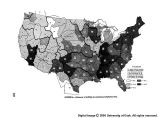
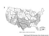
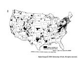
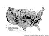
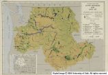
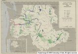
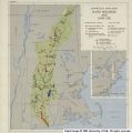
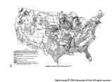
Show hydrologic cycle. Although surface water sources at present furnish several times as much water in the country as do the underground reservoirs, yet ground water is the chief source of supply for domestic and stock uses on our Nation's farms, for its small municipalities, and even for some of our larger cities. Many industrial plants and irrigation projects are dependent upon wells, and the dry weather flow of most streams stems from ground water. An evaluation of a water-bearing formation is ordi- narily quite complex. The size, shape, depth, and capac- ity of the water-bearing formation to store and transmit water must be measured by means of geologic studies, exploratory test wells, geophysical probing, and pumping tests. Water level fluctuations must be measured as a means of determining quantitative changes in storage, either naturally with time or as affected by man's activi- ties; water table maps must be prepared; areas of re- charge and discharge determined, and temperature ob- servations recorded. All these data must be analyzed and put in form for use by development agencies and by the general public. Figure 28 shows percentage of adequacy of ground water data available to the public, based on completion of in- vestigations of specific areas. On the whole, limits of water-bearing formations are not coexistent with river basins, and ground water investigations have seldom been conducted on a scale to cover drainage basins. Instead, ground water studies usually have been made on a county basis, covering county by county those areas where ground water problems have been recognized as being of sufficient importance to require these basic studies. In some in- stances, as in Pennsylvania, the entire State has been cov- ered by reconnaissance studies; in others, as in Alabama, studies have been made by major geologic units (as the cretaceous rocks, the tertiary rocks); still other States, such as Illinois, have carried on their own studies, usually at places and at times where acute ground water problems have occurred. Although installation, operation, and maintenance of observation wells are essential elements in the total ground water data picture, it has not been feasible to prepare a separate figure to indicate adequacy of facili- ties, but a large number will be required. This element has been included in the figure showing adequacy of ground water data coverage. Ground water data are available to the general public in both published and unpublished form. Of the pub- lished information, the chief sources are: (1) Geological Survey water supply reports, professional papers, bulle- tins, and geologic folios; (2) reports published by agencies cooperating with the Geological Survey, such as State geological surveys, State water boards or commissions, and State departments of conservation and natural resources; (3) State geological or water board papers published in- dependently. Only in the last 20 years-but chiefly in the last 10-have quantitative and intensive ground water studies been made. Thus, the published ground water data of this Nation, taken as a whole, are quite inadequate. Unpublished data are available in numerous Federal and State organizations. Chief sources are the Geological Survey's district offices, and State geological surveys, and Federal agencies making local studies. It is recommended that, as a general policy: (1) Effort be made to cover with reconnaissance surveys (6 to 20 percent coverage), within the next 10 years, all areas in the United States for which no ground water data now exist; and (2) intensity of coverage be stepped up in all other places in the Nation where need exists, with special attention being given to those river basins or subbasins where Federal irrigation, power, flood control, navigation, atomic energy, and similar projects are planned for con- struction or are now being constructed. Much of the study involved in this second category will be highly in- tensive (80 to 100 percent coverage). Soil Moisture Data The need for soil moisture data for the more complete understanding of the hydrologic cycle has long been recognized. A knowledge of soil moisture conditions, whether it be in the form of frost or liquid moisture, will enable the hydrologist to predict more accurately the amount of water which will percolate to ground water or will become surface flow. The moisture present in the soil at the time of flood-producing precipitation influences the quantity which becomes runoff. Soil moisture char- acteristics are also an important factor in determining the magnitude of water yields. The quantity of moisture lost from any soil by transpira- tion is determined by the type and depth of root penetra- tion of its vegetal cover, and hence, under any particular climatic conditions, the vegetal cover and the soil deter- mine the availability or nonavailability of soil moisture at any time. A knowledge of the effect of vegetal cover on soil moisture will enable the more exact prediction of water yields and flood flows. It will also improve watershed management for runoff control. Very few soil moisture data are being collected at pres- ent for hydrologic purposes. Some data were collected at scattered locations in connection with other soil and related studies, but these do not serve the general pur- pose of hydrology. These data indicate, however, the importance of soil moisture as an aid in determining run- off and the important fact that soil moisture quantities are intimately related to the rooting habits of vegetation. Very little of the data, and practically none of its interpre- tations, have been published. There are a great number of well-recognized soils in the United States and its possessions with physical charac- teristics which differentiate them from each other, and which affect their hydrologic influences and cultural capa- bilities. Soil moisture data should be obtained from an appropriate number of stations situated in contrasting soil types in forests, pastures, and croplands. As the data become available for analysis and hydrologic techniques are improved, an increasing number of sta- tions may be needed to cover more important areas. It is estimated that several thousand stations will be required over a 10-year period. It is recommended, therefore, that this program be initiated and pursued in a systematic manner in order to provide these basic data as early as possible. Chemical Water Quality Data The chemical quality of surface and ground water is directly related to its suitability for a great variety of purposes. The concentration of dissolved mineral matter, 911609-5C 343 |


