| OCR Text |
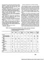
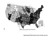
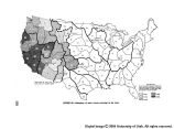
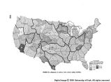
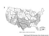
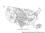
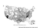
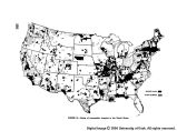
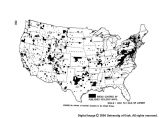
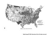
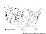
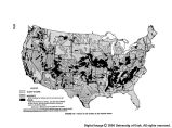
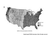
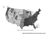
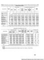
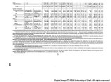
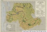
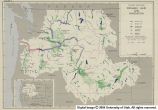
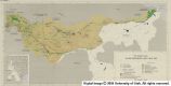
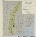
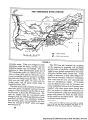
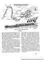
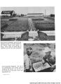
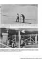
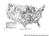
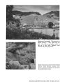
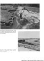
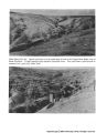
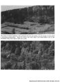
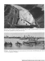
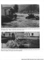
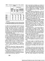
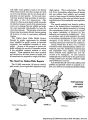
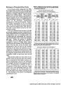
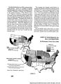
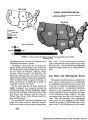
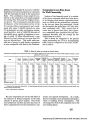
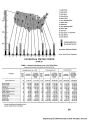
Show Snow-cover data in New York and the New England States are not considered complete. Additional stations at higher altitudes would be helpful. More snow-cover data would aid materially in determining the water avail- able for municipal water supply and would permit more efficient watershed management and operations of hydro- electric power plants. Additional snow-cover data are also required to provide information on the recreational aspects of snow. For this purpose data should be col- lected frequently and distributed promptly. The installation of 550 snow courses in the West is recommended. This represents an increase of about 55 percent over the present number. Installation of about 100 stations, an expansion of about 25 percent, is recom- mended for the Northeast. To meet requirements for snow-cover data for the entire United States about 100 additional stations should be placed in the North Central States. Surface Water Data Total stream flow from an area represents in most cases the upper limit of water potentially available for sustained development from both surface and underground sources. Stream flow is the integration of all factors as they affect the movement of water through and over the land. It is the end product of a long chain of events. By far the largest source of water used in the United States is surface waters. Streams and lakes not only supply roughly three-quarters of the water used for mu- nicipal supplies and for irrigation, but also supply the larger part of the water used by industry. Important uses of surface water take place in natural and artificial chan- nels for navigation, production of hydroelectric power, recreation, and dilution of wastes. Most of the uses of surface water mentioned are achieved by the construction of structures for the regulation and distribution of stream flow. Flood protection requires con- trol works, such as reservoirs, levees, or dikes. Stream- flow data are used in the design of these structures to assure safety and economy. Large expenditures for operation of existing works and the sums contemplated for future river developments makes the collection of reliable basic data on stream flow a precautionary and economic necessity. Analysis of actual stream-flow records give the only reliable information on floods, total flow, maximum flow, minimum flow, and time duration of flow. For the many ungaged streams, other hydrologic studies backed up by spot discharge measurements and ground-water investi- gations are necessary. Long-term stream-flow records from a base network of gaging stations are fundamental to such hydrologic studies. The more closely spaced these base stations are and the more representatively located, the more reliable will be hydrologic analyses. Records of stream flow are regularly collected at about 6,000 gaging stations. The network of stations covers all States in variable amplitude. There are broad areas, chiefly in the West and on small streams in all parts of the country, where the number of gaging stations is inadequate. The variability of runoff in place and in time empha- sizes a need for long-period gaging of most rivers. Water resources of the United States can be adequately evaluated only by assured continuity in gaging. Continuity is vital because of the possibility that a once-in-a-lifetime flood or drought may occur during a short lapse of time. It is estimated that temperature observations are being made once daily at approximately 200 locations on surface streams throughout the country. Relatively few auto- matic water temperature recording instruments are cur- rently in use on surface streams other than those that may be operated in connection with private industrial plants. Information about temperatures of surface waters is essential for many industrial purposes. The location of certain industries is dependent in large part on tempera- tures favorable of available water supply. Surface water temperatures are also needed for determining suitable water supplies for fish and wildlife and for recreational purposes. Basic information of our surface water resources is derived primarily from stream gaging stations, and from lake and reservoir stage gages. Most of these are oper- ated by the Geological Survey. Adequacy of coverage of stream gaging facilities is based upon the ratio of the number of existing stations to the total number of stations required. The percentage of adequacy is shown graphi- cally for subbasins on figure 27. This figure shows the adequacy of data-gathering facilities to be less than 60 per- cent in 54 of the 79 subbasins, and to exceed 80 percent in only 1 of the 79. Although the length of record is an extremely important factor in determining adequacy of surface water data, that element is not reflected in Figure 4. It must be recognized that the determination of adequacy is not absolute but is a matter of judgment, and that it is not fixed but will change as present needs disappear and as additional needs develop. In addition to collection and computation of basic data, certain special analyses of these data are needed to permit the Federal Government to fulfill its responsibility for a comprehensive Nation-wide program of appraisal of the surface water supply and its utilization. These analyses include, but are not necessarily limited to, flood frequency and time-duration studies, indices of water data, compilation of published water data, and evaluation of stream flow records. Many agencies have made analyses of stream flow data in connection with studies performed by them, but for the most part this information is not generally in a form convenient for public use. The number of existing surface water stations (stream gaging, stream stage, reservoir, and lake) in the con- tinental United States is approximately 6,300 and the number of proposed additional stations is 5,800. It is recommended that (1) the installation of the proposed 5,800 stations be carried out progressively during the next 10 years in order that data required for planning, design, and operation should be available for these purposes, and (2) correspondingly expanded analysis and special study of past and present records should be undertaken so that the maximum benefits can be derived from all available data. Daily temperature records should be collected at about 3,000 stream-gaging stations. Where once-daily observations are inadequate it is recommended that about 100 water temperature recorders be installed in the United States. Ground Water Data Available ground water data are among the most in- complete of all those essential for an understanding of the 341 |