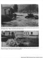
| OCR Text |
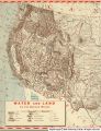
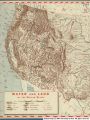
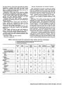
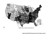
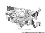
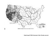
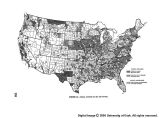
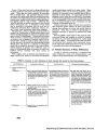
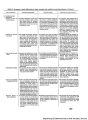
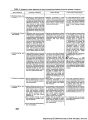
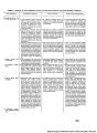
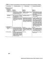
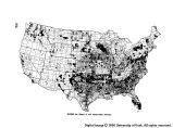
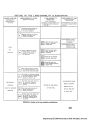
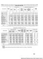
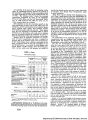
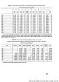
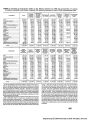
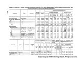
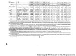
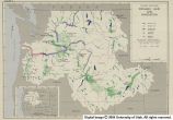
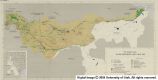
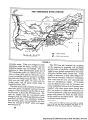
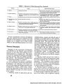
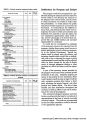
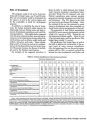
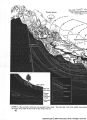
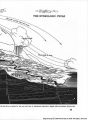
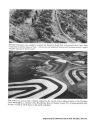
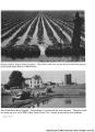
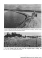
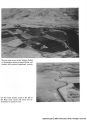
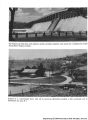
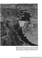
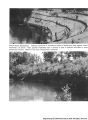
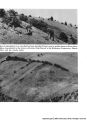
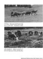
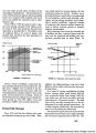
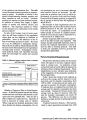
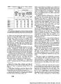
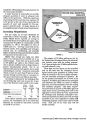
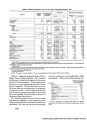
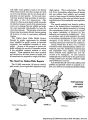
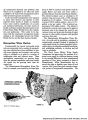
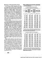
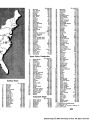
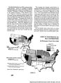
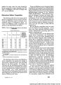
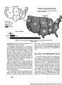
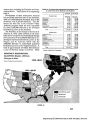
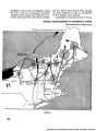
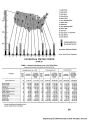
Show this planning stage considerable expense is warranted for processing and summarizing all existing data. Such analy- sis will reveal deficiencies in network density and pattern. This phase is most advantageously served by national observation programs. Depending on the item, continu- ous or periodic observations are required for relatively long periods of time to gain knowledge of possible extremes of the factors. The principal items of hydrologic data re- quired for the general coverage phase are: Precipitation.-Full utilization is made of all published summaries and unpublished data are compiled and sum- marized. Needs for more intensive coverage within the projects area beyond that afforded by basic networks should be considered and the necessary stations established at the earliest possible date. Evaporation and other meteorological elements.-All available data are used in this phase of data collection. Additional stations should be established if the basic net- work is considered inadequate for the purpose of the project or program. Long-term records are most desirable. Surface water.-Data from a long-term network of stream gaging stations should be available. Collection of any additional data found advisable should be undertaken as early as possible because the value of stream-flow records increase with length of period covered. Ground water.-Comprehensive regional studies of ground water hydrology are required in this phase. Then studies require knowledge of the dimensions, geologic structures, the yields, and other hydrologic properties of aquifers. Such essential data cannot be obtained at once as water level fluctuations determinations of safe yields in rates of recharge of ground water require many years of record to be o>f optimum value. Chemical quality of water.-Information about the chemical quality of surface waters is determined by the establishment of stations on streams to collect daily and intermittent samples for laboratory analysis. Records covering several years are desirable especially for those streams that are highly variable in turbidity and chemical quality or where these factors are expected to change. Provision should also be made for systematic sampling of ground waters; to determine their quality. Sanitary quality of water.-For each source of pollution by sewage and industrial wastes, data must be collected on the flow, strength, and character of the pollution, and on the physical, chemical, bacteriological and other biological changes in the stream resulting from pollution. Sedimentation.-Sediment sampling stations should be established to obtain sediment load characteristics of the streams under consideration. Reconnaissance sedimenta- tion surveys o£ representative reservoirs in the area, valley cross sections of sample subwatersheds to measure valley fill and damage to bottomland caused by sediment, sample mapping of sediment source areas to determine relative amounts and character of sediments derived from various types of erosion, and similar studies should be made in this phase. Topography.-Topography for this phase should be recorded on general-purpose maps giving systematic large- area coverage. Maps should show relevant details necessary for a general inventory of the area, normally at scales of about 1 inch equals 1 mile, or 1 inch equals one-half mile. Preferably, maps should be made available for the entire project area. Deficiencies in topographic mapping are so great, however, that often the project area cannot be entirely covered in time for the maps to be of fullest use. In such cases, close coop- eration between the development agency and the data collection agency in inaugurating mapping programs is required for areas; first, where information is most urgently needed, and other areas, in turn, to meet needs of development progressively. Geology.-General coverage for geologic data, like that of topography, should be general purpose in nature. Geologic maps and subsurface sections are basic facts in determining the soundness of a project or program, and should be in sufficient detail to insure such a determina- tion. Geologic maps and subsurface sections must pro- vide information on workable mineral deposits in the area so that the significance of such deposits may be con- sidered in determining the economic feasibility of pro- posed projects. Geological studies are also a basic and integral part of investigations for ground water supply. Generally, geologic features are mapped at scales of 1 inch equals 1 mile. Soils.-Under this phase of data collection, basic soils data are needed to show boundaries and areas of soils having different inherent characteristics and properties. Such data are best presented at scales which fit the needs for showing soils in classes or associations that are reason- ably uniform in their principal observable characteristics. Standard topographic maps, where they exist, furnish the best base map for recording information on soils. In water and related land resource development, data on certain characteristics of soils are required for estima- tions of rates of infiltration and percolation, for deter- mining storage capacities of soils and underlying material, and for erodibility, under various uses, as well as other properties of soil types and associations. Vegetation.-Information on density and condition of natural vegetal cover, as well as condition of croplands, is required for planning watershed programs and in carrying out measures and practices of watershed man- agement. Preparation of maps showing the natural cover and its condition is the first step in the assemblage of such data. More detailed information is obtained as required. Cadastral surveys.-Before development of the water resources can be undertaken in areas of intermingled public and private land, boundaries and limits of owner- ship must be established. The cadastral survey of the public domain constitutes a basic fact for any resource consideration of the public lands. Fish and wildlife.-In connection with the general coverage phase of data collection, it is necessary to obtain all pertinent data of fish and wildlife, to collect and compile readily available biological data, and to conduct fairly detailed biological investigations of the project area. Socio-economic data.-Socio-economic data collected in this phase provides a financial and social basis for project justification and authorization; therefore, it is the most important phase of economic study. The entire field of socio-economic data may be required in the survey stage, but the amount and kinds of data, as well as the emphasis to be placed on the individual items, depend in any one investigation upon the nature of the project and program. See table I. Typical kinds of economic data 332 |