| OCR Text |
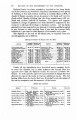
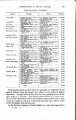
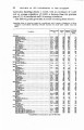
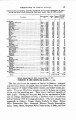
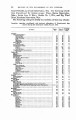
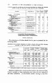
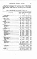
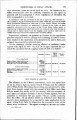
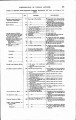
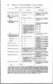
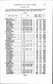
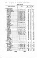
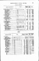
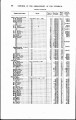
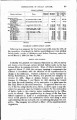
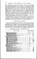
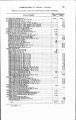
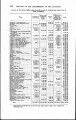
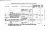
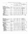
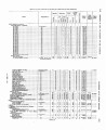
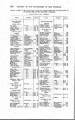
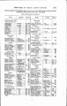
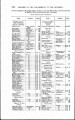
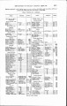
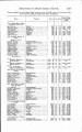
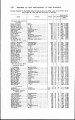
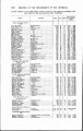
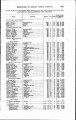
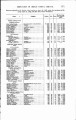
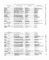
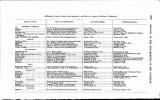
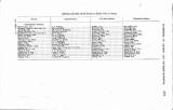
Show line. Permission was granted on January 6,1905, to survey through the Shoshone Reservation from a point on the eastern boundary about midway between the north and south line, southwesterly to the south boundary, and also from the north line near Thermopolis southerly to a connection with the former line. Maps showing the definite location of the first-mentioned line were approved by the Department on July 28, and maps have been submitted to the Office for approval, showing the line extending southerly from the north line of the reservation. The maps are held pending the expiration of the twenty days after service of notice on the agent. This railroad follows the lines of the surveyed route of the Wyo-ming State Railway Company. The last-named company has, by arrangement with the Wyoming and Northwestern Railway Com-pany, consented to the use by that company of its right of way. OKLAHOMA AND INDIAN TERmOBY. The act of February 28,1902 (32 Stat. L., 43), governs with respect to grants for railroad rights of way and additional grounds in Okla-homa and Indian Territory. Maps filed under this act are not sub-ject to the approval of the Secretary of the Interior. The following table shows the maps of this character filed during the last fiscal year: Ralrooad map8 filed mdw wt of BeDwbru 28, 190% Name of oompany. 1 R.ig ht of Add~tlonal I inis. |