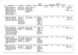
| OCR Text |
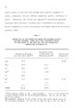
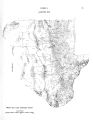
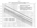
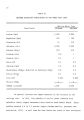
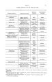
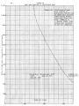
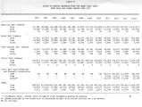
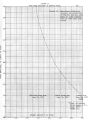
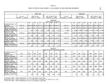
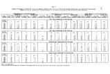
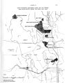
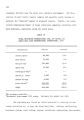
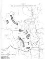
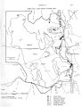
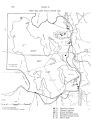
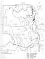
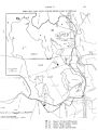
Show 38 on July 13, 1939. The second highest of 111 degrees was observed at Antelope Island on July 25, 1959. The lowest temperature recorded near the Lake was 32 degrees below zero and occurred at Corinne, Utah, on Christmas Day, 1924. The record minimum in the Basin was measured at Lewiston, Utah, in Cache Valley, 44 degrees below zero. Thus, the annual range of extreme temperatures in the Drainage Basin has been 156 degrees. The average number of days with a high of 90 degrees or higher during the 10- year period from 1951 to 1960 ranges from 72 days at Antelope Island to 23 days at Park Valley and Tooele, Utah. Precipitation The precipitation regime in the Great Salt Lake Basin shows marked seasonal variation. The heaviest precipitation occurs during the spring of each year with a secondary maximum during the fall. These two periods are associated with upper- air low- pressure systems ( locally called Nevada lows) and with eastward- moving storm fronts from the Pacific Coast. Winter precipitation results mostly from the passage of active storm fronts with a marked reduction in the Nevada low activity. A small tertiary maximum precipitation occurs during the latter part of July and August as the northward flow of moist air from the Gulf of Mexico reaches its peak. This moist air is unstable and, as a result of topographic and convective lifting, thunderstorms are produced. In the Salt Lake City area, there is an average of 35 thunderstorm days per year. The driest time of the year is during the last week of June and the first week of July, a transition period between the retreating Pacific air masses and the advancing thunderstorm activity from the south. A |