| OCR Text |
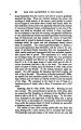
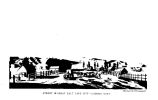
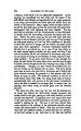
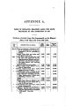
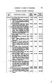
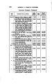
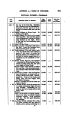
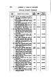
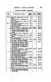
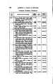
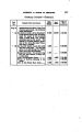
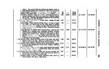
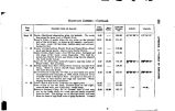
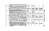
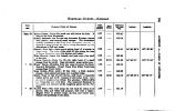
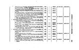
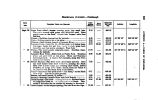
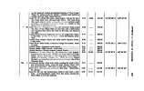
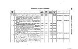
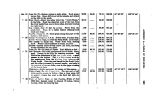
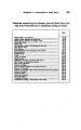
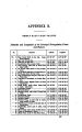
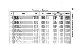
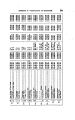
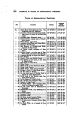
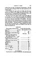
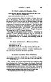
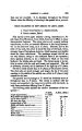
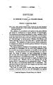
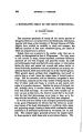
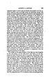
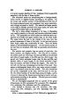
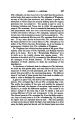
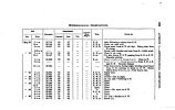
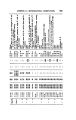
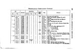
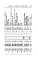
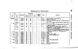
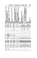
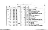
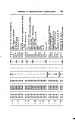
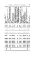
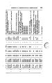
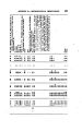
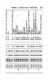
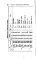
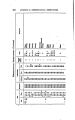
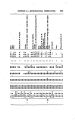
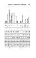
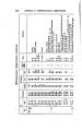
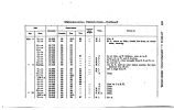
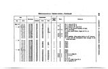
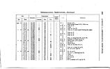
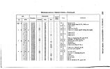
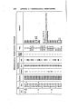
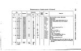
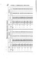
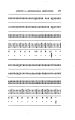
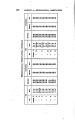
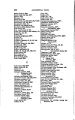
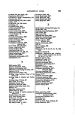
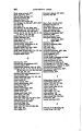
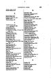
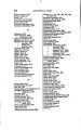
Show 300 APPENDIX fc.-^ TABLE OF GEOGRAPHICAL POSITIONS. TABLE OF GBOGBAPHIOAL POSITIONS. I860. LOCAUTOS. No. " 8 " 4 " 5 " . 6 " 7 u 8 -" % 9 " 10 \ i M u ; 12 " 18 " 14 " 16 « 16 •* 17 " 18 * 19 " 20 " 21 J* 22 " 28 " 24 " 26 •* 26 " 27 " 28 " 29 " 80 « 31 " 82 ' « 88 • « 84 N 35 " 86 Adobe Hall, Great Salt Lake City. The longitude from Col. Fremont. Junction of Forks of Golden Pass Creek; near point of union of old and new roads. Binding ridge, Wahsateh chain Parley's Park; spring east of Bauch- ' mill's Creek. Weber Hirer; upper ford Junction of Red Fork and Weber Hirer. Spring in Red Kanyon. Red Kanyon at Chicken- cock Bluff; junction of Echo Creek. At Yellow Creek, tributary of Bear Hirer. . Sulphur Creek: one mile east of Bear Rirer Ford, and north of Tar Springs. Copperas Spring, in Great Coal Basin... Fort Bridger :. ;... Black's Fork, near Muddy Creek .. Near Spring on the plain, in the bend of Black's Fork. East bank of Gitoen Hirer, Bitter Creek „ Bitter Creek,- at the Sandstone Bluffs... Bitter Creek Prairie > ... Bitter Creeks head spring branches.... Bridger's Fork of Little Snake Hirer... On the plains of Muddy On the west bank of Muddy Fork, a branch of Little . Snake Hirer. North'bank of the Muddy, near Vas-ques' battle- ground. In the Kanyon of Muddy Fork. On a rirulet near. Bridger's Pass Branch of Sage Creek On North Platte. The longitude taken from CoL Fremont's maps, 1848. On the plain west of Medicine- bow Mountain. Rattlesnake Creek, near Medicine- bow Butte. Laramie Plains Laramie Plains ..< F^ appe's Creek On route across Laramie Plains......*... West Fork of Laramie Rirer. *. / 2.72 miles west of Laramie Rirer; Main Fork. In Black Hills; on a branch of Crow Creek. 40° 46' 08^. 8 40° 46* 40* 5 40* 44' 48" 40* 48' 04". 8 40° 68' 41". 8 40° 67' 41". 07| 41° 02' 27". 26| 41Qt) 6' 26". l 41° 09'<) 0". 2 l41* 08' 08". 18| 41° 18' 46". 7 41* 18' 12". 8 4i° 28' 66". 88 41° 81' 08". 5 41° 3< y 44". tf 41° 84' 4< T. 8 41° 80' 51". 4 41° 28' 09". 2 410 24' 12" 41° 28* 89" 41° 28' 14". l 41Q27' 06". 18| 41* 28' 28". 49| 41° 27' 41" 41° 88' 22", 8 41* 85' 21" 41° 82' 49", 2 41° 87' 16". 8 41° 40' 45". 2 41° 41' 50", 9 41° 88' 88^. 6 41° 88' 06" 41° 28* 16'? 41° 19' 48". 4 41° 15' 4l". 4 41° 08' 02" 112° 06' 08" 111° 68' 14" 111° 46' 6S". 6 lll° 88' 46T. 2| 1110 86' 26" 111° 40' 46" 111° 80* 84" 111° 22' 06" 111* 14' 18" 111° 01' 22" 110° 48' 00" lfl)* 82' 2r 110° 18' 60" 110° 04' 15" 109° 88' 40" 109° 28' 09" 108° 60* 84" 108° 41' 09" 108* 81' 00" 108° 14*- 24" 108? 02' 11" 107° 62* 41" 107° 41' 21" 107° 88' 48" 107° 80' 48" 107° 21' 62" 107° 06' 11" 106° 68' 81" 106* 48' 87" 106* 86' 67" 106° 24' 47* 106° 16' 68" 106° 06' 86" 106° 6712" 10$° 46' 89" 106° 24' 11" |