OCR Text |
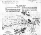
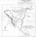
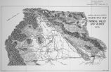
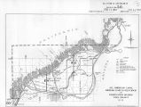
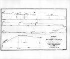
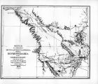
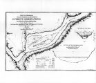
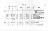
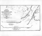
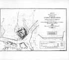
Show 338 REPORT OF THE CHIEF OF ENGINEERS. line of levels was run from Fort Yuma to Indian Wells, and to the dry camp beyond. Tbe profile shows that there is a steady descent, with but few breaks, from the altitude of 137.8!) feet at Fort Yuma to 38.8 feet below sea-level at a point 6} miles west of Iudian Wells. From this point the rise is rapid and constant up to the mountains which border the desert on tbe west. One of the branches of New River leaves the Colorado near Algo-don station, and this artificial channel might be utilized in the construction of a canal fur diverting the water of the river into the depressed area to the northwest/ The exact course of this canal cannot be determined without further surveys, but it seems probable that it would be necessary to run it below the boundary-line nearly as far as Seven Wells in order to avoid the sand ridge. From this point it could bend more or leas toward tbe north, according to tbe downward (dope of the surface in that direction. The amount of cutting required is difficult to estimate without further surveys, but it would doubtless be moderate, as the water flows into this area from the river when it overflows its banks. From several persons who have resided for years in this section I have obtained the following information witb regard to the flow of the water through New Kiver and changes in the lied of the Colorado. Mr. Hanlon, owner of the ferry at Hanlon's Ferry, 7 miles below Fort Yuma, says : "The channel of tbe Colorado opposite Pilot Knob in now about three-fourths of a mile east of where it was at the time of Mr. Wozencroft's examination. It then runs close to the point of rocks which jut out from the eastern base of Pilot Knob. In June and July, 1801, there was a great overflow. The current at Alamo Station was more rapid and four times greater in volume than at Fort Vuuia now, (March, 1870,) water flowing to the northwest toward the desert." Mr. McMasters, station-keeper at Algodon, nays: "Thegreat sand billows southwest from Pilot Knob are constantly moving toward the south, caused by the prevailing north winds. There has been uo overflow for thrw-years. During years of unusually high water in the river the water was 2 feet deep in the station-house, which is GOO yards from the river. (Jndging by the depth of water in the well at the present time, the river must have risen about 17 fret above its ptv*-ent stage.) Captains Poole and Pol hem us, of the Colorado Steamboat Line, say that up to 1804, during Hummer, at high water, boats took slough at base of Pilot Knob. The highest floods occurred in 180*2 and 1807." Mr. Conners, engineer on steamboat, says : "Crossed N«w River at Indian Wells in July, 1-0*2. Water 7 feet deep and flowing north. Volume about twice that of the Los Angeles River in July." Mr. Redondo, butcher at Yuma, says : "Slough from Algodon runs to New River, and from then; came the water of New River during the heavy flood of 1*0*2." Mr. Jaeger, owner of ferry at Fort Yuma. and a resident of the place .since its establishment as a military post, says: " Heavy floods in 1840, l-fig, 1*30, IWS, and 1*07.'' Tasted the water flowing in channel at New Kiver Station in 1 "0*2, and found it fresh water. A Mr. Jones (now dead) told me. that he came along the west side of the great desert basin in 180*2, on his way from San Bernardino to New Kiycr, and saw in tin1 basin a great lake some 00 miles long by 30 wide. This came from the overflow in 180*2. From information obtained and examinations nude, it may be taken for granted that there is a current which sets in along the channels of New Uiver during high floods, and that this current flows toward the north into the depressed area. At th>-same time, a large portion of the country between Pilot Knob and Mount Purdy is submerged, ns are also portions of the plains or meadows l>etweeu Signal Mountain and Indian Wells. On the subsidence of the water these plains soon become dry, ami also the different channels of New River, except in the deeper portions, where reservoirs are formed, in which water remaius for a year or more, depending on its depth. Several questions of ini|x>rtance remain to lie considered in this connection, such an probable difficulties and cost of keeping the channel free from sand blown in from llw sand-hills, as well as from the settlement of the sediment in the water. These cannot be determined without closer investigation and a more detailed survey. The area of the depressions below sea-level can !><> obtained approximately from data obtained from Southern Pacific and Texas Pacific Railroad surveys, together with the level-lines run by my party. The accompanying sketch shows the outlines of this area, as well as the direction and extent of the lines of profile, and altitude* at different points; these altitudes all lx-ing referred to the Southern Pacific Railroad Im-ih-Ii-maik at Fort Yuma. From these data it appears that the northern limit of the depression is near Indian Wells, in the Coahuila Valley, and extends westwardly below the Mexican boundary. This given an approximate area of nearly 1,000 square uiile* lying within the limits of California. |