| OCR Text |
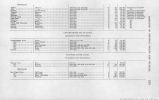
Show YAMPA BASIN-Continued. to o Stream. South Fork........ Middle Fork....... Slater Fork;....... Savery............ Willow Creek...... Four Mile Creek... Muddy Creek...... Stations. Goodard Ranch........ .....do.................. Baxters Ranch......... Savery, Wyo........... Ryans Ranch.......... Ranger Station......... Baggs, Wyo............ Period of records. 1912-1920....... 1912-1920........ 1912-1920....... 1915-1920....... 1912-1920........ 1912-1920........ 1915-16 and 1918. Years. Drainage Square miles. 41 120 80 354 8 8 3 Elevation. 7,000 7,000 7,000 7,600 7,500 Mean annual recorded run-off. Acre-feet. 33,000 100,000 61,400 80,300 7,650 5,460 36,800 Remarks. WHITE BASIN. [Arranged in order downstream.] Stream. Station. Period of records. Years. Drainage area. Mean annual recorded run-off. Remarks. White River... To......... North Fork___ Do......... Marvine...___ South Fork___ Piceance Creek. Meeker.. Rangely. Bufford. .do. do___ do___ At mouth. MISCELLANEOUS-GREEN BASIN. Beaver Creek..... Vermillion »_reek. Lodore ....do. 1891-1906 and 1910-1920.......... 1904-5 and 1918.................. 1903-1906........................ 1910-1915 and 1919-20............ 1903-1906........................ 1903-1906, 1910-1915, and 1919-20. 1918............................. 1910-*.. 1910-11. Sq. miles. 634 3,266 181 240 50 148 642 27 1,017 Acre-feet. 468,000 549,000 245,000 90,100 210,700 20,000 100,000 At mouth Insufficient data. Rough. |
| Source |
Original book: [State of Arizona, complainant v. State of California, Palo Verde Irrigation District, Coachella Valley County Water District, Metropolitan Water District of Southern California, City of Los Angeles, California, City of San Diego, California, and County of San Diego, California, defendants, United States of America, State of Nevada, State of New Mexico, State of Utah, interveners] : |


