OCR Text |
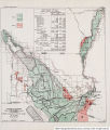
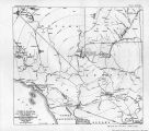
Show 72 PROBLEMS OF IMPERIAL, VALLEY AND VICINITY. This project involved a grant of Government land to California amounting to about 3,000,000 acres. It was approved by the Legislature of California, but the necessary bill failed to pass Congress. Subsequently an examination was made under Government direction to determine whether or not it would be feasible to reach the Imperial Valley without following a route through Mexico. This examination was made in 1876 by Lieut. Eric Bergland, Corps of Engineers, United States Army, who acted under the direction of Lieut. George M. Wheeler. He reported unfavorably upon a canal location entirely in the United States, but again called attention to the natural route across Mexican territory. Despite this report, which was discouraging to those who desired to have water supplied to the desert in a canal located throughout its entire length on United States territory, the efforts to get water into Imperial Valley did not cease. But no proposition gave promise of success until Mr. C. R. Rockwood and his associates organized the Colorado River Irrigation Co. in 1892. Surveys were made and works were planned to deliver water from Colorado River in California across the boundary into a short canal in Mexico, which would discharge into the Alamo River, down which it would then flow to a reentry into California. This company failed, however, and was succeeded in 1896 by the California Development Co. At the head of this company, except for two years, 1900-1902, was the late Mr. A. H. Heber. Mr. Rockwood remained in charge of engineering and construction. A reorganization of the company in 1905 put the control of its affairs into the hands of the Southern Pacific Co. From 1910 until 1916 the property of the canal company was in the hands of a receiver. In 1914 the Imperial irrigation district was organized and two years later took over the canal properties, which included all the shares of stock of the Mexican corporation through which the properties in Mexico are managed. The canal of the California Development Co., as originally constructed, had its head in California at Hanlons or Hanlons Crossing, about 100 yards north of the international boundary. The canal was cut from the river at an oblique angle, and its flow was controlled by a timber structure. On a falling river the head of the can.al and the head-gate were obstructed by silt deposit, and it became difficult to keep the water flowing from the river into the canal. The water shortages due to this cause in 1903 and 1904 and the failure of various remedial measures prompted the application to Mexico for a concession under which a diversion would be allowed on Mexican territory. This concession was granted in 1904, and operating thereunder the dredger cut was made about 4 miles below the boundary line in Mexico, which caused the river a year later to turn for a time inland away from its course to the Gulf. The concrete headgate of the Imperial Canal at Hanlon, which was constructed in 1906, has a sill at elevation 100.7 feet above mean sea level. (U. S. Geol. Survey datum.) This was at that time believed to be low enough to accomplish diversion of the desired amount of water at any stage of the river. The large amount of sand which has annually been carried into the canal and the depression of the water surface in the river below the assumed minimum elevation have combined to make the diversion of an adequate quantity of water at the river's low stages impossible. This is true despite the fact that a few years ago a 25-foot section of the headgate sill was lowered 5 feet. Imperial irrigation district has, therefore, found it necessary to construct temporary weirs across the river of rock and brush. Such a weir was constructed in 1910 and annually since 1915. ' There is some water obtained for the irrigation of lands in the Imperial irrigation district and in Mexico from Volcano Lake through the Cerro Prieto Canal. This is only if temporary expedient. The connection of the Cerro Prieto Canal with Volcano Lake was made in 1916. Water has thus been made obtainable from the Volcano Lake. region while the river is high. As this water is drawn from an extensive ponded area it is comparatively clear, and its use has materially reduced the difficulty with silt in the. west-side canal system. The maximum amount of water obtained from this source has exceeded 800 second-feet. This source of supply will be available only so long as the river is allowed to send its flood waters against the Volcano Lake Levee. The time will come when the river is put back upon a direct course to the Gulf, and thereupon this source of supply will no longer be available. (All-American Canal report.) Regarding flood-protection problems of the imperial Valley, the following is from report of Mead, Henny, and Jacobs on "Irrigation and flood-protection problems of Imperial Valley, Calif., March, 1917: * * * In 1891 so much water flowed over the western bank that it found its way through the dense bordering growth of brush and weeds and reached the lowest part of the Sal ton Sink; not, however, for a long enough time or in sufficient volume to effect a permanent channel change. |
Source |
Original book: [State of Arizona, complainant v. State of California, Palo Verde Irrigation District, Coachella Valley County Water District, Metropolitan Water District of Southern California, City of Los Angeles, California, City of San Diego, California, and County of San Diego, California, defendants, United States of America, State of Nevada, State of New Mexico, State of Utah, interveners] : |