| OCR Text |
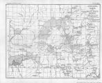
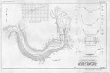
Show PROBLEMS OF IMPERIAL VALLEY AND VICINITY. 01 CIBOLA VALLEY PROJECT. Location and description.-The Cibola Valley lies on the east side of the Colorado River in Yuma County, Arizona. It is about 20 miles south of the lower end of the Parker Valley and is adjacent to the lower end of the Palo Verde Valley, being separated from the latter only by the river. The nearest railroad point is the new town site of Ripley in the Palo Verde Valley, about 12 miles north. The general elevation of the valley is about 230 feet above sea level. The valley lies north and south; with a length of 12 miles and a mean width of 3'miles. The Cibola Valley is "but little above the bed of the stream, and the entire area is subject to overflow during normal high water. The valley could not be developed without complete storage control or without a levee for the full length of the river bordering tne valley There is no diversion dam site in the vicinity of the Cibola Valley. A topographic survey was made on the scale of 2 inches per rnile in 1902 and 1903. There has never been any irrigation development in this valley except a few attempts on a very small scale of individual pumping. Some farming on a small scale has been practiced on overflow lands. An irrigation district was formed by the landowners in 1913 for the purpose of developing an irrigation project. Detailed surveys of an irrigation and levee system were made for the district by R. L. Morton in 1914. From these surveys a complete system of canals, levees, and drains was designed and quantities computed, and a report and estimate were made covering the same by C. K. Clarke in 1914. The plan as laid out by Mr. Clarke is shown on Plate XVIII, which was copied from a large-scale map prepared by him. The irrigation district voted bonds for the construction of the project as outlined and estimated by Mr. Clarke, ^but te the present date no market has been found for them. Drainage.-The sloughs above mentioned are sufficient for carrying off the surplus water, except during high water of the river when the valley is subject to overflow. With the development of irrigation, however, artificial drains will be necessary. These sloughs can be used to a large extent in the construction of a drainage system. ; Ownership and area.--The area of the project and the status of the lands, as of October, 1920, as shown by the records of the United States land/office, are as follows: Classification of lands, Cjbola Valley project. tJross. Net. Entered... Patented Public State ! Total. 3,000 8,000 5,500 2,000 2,550 6,800 4,650 1,700 18,500 15,700 |
| Source |
Original book: [State of Arizona, complainant v. State of California, Palo Verde Irrigation District, Coachella Valley County Water District, Metropolitan Water District of Southern California, City of Los Angeles, California, City of San Diego, California, and County of San Diego, California, defendants, United States of America, State of Nevada, State of New Mexico, State of Utah, interveners] : |


