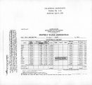
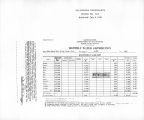
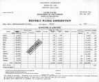
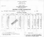
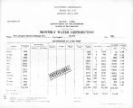
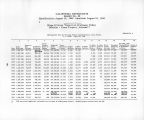
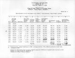
| OCR Text |
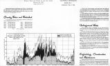
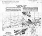
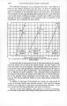
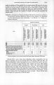
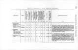
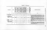
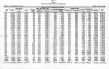
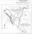
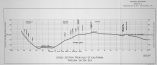
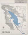
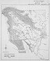
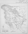
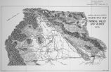
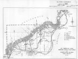
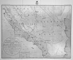
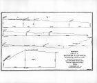
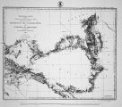
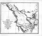
Show REPORT OF THE CIIIEF OF ENGINEERS. 293 inent will in no wise invalidate the claims of the remainder of this great State to the rank it has so well taken among the greater grain-producing States of the Union, no more than it accuses nature in being canton in the disposition of its fields for the uses of mankind. That part lying east of the summit of the Sierras, where the rainfall immediately changes .from one as great as 40 to 50 inches to G, 8, and 10 inches annual fall, is not included, and is in addition to the area of 45,700 square miles mentioned. The part of Nevada shown is that portion least inhabitable from an agricultural point of view. While in all these desert sections mines have been and are still lx'ing found, oftentimes in suflicicnt proximity to water to warrant their l»eing worked, still little underground exploration, even, has been undertaken, except in a few localities. Jloads across this section of the country have been few, and the danger of exploring away-from the main ones is the principal hinderance to the hardy prospector in his labors. 1 )r. Loew speaks of the wonderful change noticed by every traveler in crossing the summits of the Coast range south of Tehachipi Pass, found to exist between the desert and const Horn. This report will doubtless piovc interesting. (See Appendix II 7.) The basin drained by the Colorado Itiver of the West comprises approximately 241,tM>5 square miles, or approximately 154,S57,«;O(I acres, composed of valley, plateau, and mountain section in wonderful variety, portions of which have been laid out into the following political divisions: California, Nevada, Utah, Wyoming, Colorado, New Mexico, and Arizona; and prior to its exit into the Gulf of California it washes the eastern shore of Lower California and the western shore of part of Northwestern Mexico. The length of the river from the junction of the Grand and Green is approximately 875 miles. Its elevation at Hanlon's Ferry, near Fort Yuma is 120 feet; at the grand bend to the south, near head of Black Caflon, 900 feet; at the junction of the Green and Grand rivers, 3,800 feet, from whence the name Colorado begins. It is essentially a canon river until it leaves the territory of the United States, when its character in this regard materially changes, and with it the peculiarities of erosion and alluvial depositions in vicinity of its shifting bed, while opportunities for diverting the same are more likely to be found. The climate along its banks varies partly with the elevation, but more largely with the amounts of rainfall, which, until reaching the Grand Canon, may be said to vary from £ to 10 inches annually. In portions near the sources of Grand River, in the high, mountainous regions of Colorado, the rainfall increases somewhat In proportion to the altitude, and without any specific data on the subject it is safe to say that it reaches 40, if not a larger number of inches annually; but the areas showing the larger amounts of precipitation are comparatively small, and confined to the narrow valleys of the main stream and their side branches within the mountainous portions proper. No such amount of rainfall is known iu any part of the Green River Basin, even at its source. Very little of this valley is available for agricultural purposes, and it would be difficult to improve large tracts of land along the main stream or any of its immediate tributaries. The districts, then, into which the entire valley-drainage of the Colorado area may be divided are as follows: First, the more desert parts, bounded on the east by the western mesa wall of the Lower Grand Cafion, which is limited in extent on the north by the rim of the great interior basin near the Nevada and Utah line, and extending southward by the heads of the Salt and Gila rivers to the continental divide. Within this area there are strips of considerable size |