| OCR Text |
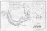
Show Appendix A. REJPORT OF BOARD OF ENGINEERS ON DESIGNS AND COST ESTIMATES OF BOULDER CANYON DAM. WITH SUPPLEMENTARY REPORT OF OCTOBER 26, 1921. May 26, ,1921. From: Board of Engineers. To: Chief Engineer, Denver, Colo. Subject: Report on Boulder Canyon Dam, Colorado River. 1. The undersigned board of engineers met at Boulder Canyon dam site on May 13, 14, and 15, 1921, to consider preliminary investigations, tentative designs, and cost estimates of the Boulder Canyon Dam. exhibits. 2. Attached hereto you will find plates showing topography, profiles, and a preliminary design of dam, as follows: Plate VII: Boulder Canyon Dam sites, topography and profiles. Plate VIII: Boulder Canyon Reservoir, river-bed section, A dam site. Plate IX: Boulder Canyon Dam Reservoir, river-bed section, C dam site, line C-l. Plate X: Boulder Canyon Reservoir, C dam site, line C-2. Plate XI: Boulder Canyon Reservoir, preliminary design, curved gravity dam. DAM SiTES INVESTIGATED. 3. Two dam sites have been investigated and explored in a preliminary way with diamond-drill equipment. The two sites are about 2,900 feet apart, the upper one being some 3,500 feet downstream from the head of the canyon as determined by Boulder Wash. The lower site is known as the A site, while the upper one has been designated the C site. 4. The rock in the canyon walls is a fine-grained granite of excellent quality although jointed to a considerable extent. The walls rise precipitously from river elevation to heights of from 1,200 to 1,500 feet and then continue upward on a flatter slope and more irregularly to the higher peaks of the mountain range. 5. The river through the canyon varies in width at low-water stage from about 200 to 500 feet, the narrowest point being at the C dam site. At low stage the water is about 10 feet deep. 6. The results of the investigations made thus far indicate that bedrock will be found at depths not exceeding 140 feet below low-water surface. At the A site the greatest depth at which bedrock was reached is 137 foot, while at the C site it was reached at 130 feet. In general the river trench is filled with about 50 feet of boulders overlaid by 70 feet of sand. The largest boulder encountered in* drilling was 10 feet through. |
| Source |
Original book: [State of Arizona, complainant v. State of California, Palo Verde Irrigation District, Coachella Valley County Water District, Metropolitan Water District of Southern California, City of Los Angeles, California, City of San Diego, California, and County of San Diego, California, defendants, United States of America, State of Nevada, State of New Mexico, State of Utah, interveners] : |


