| OCR Text |
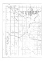
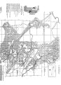
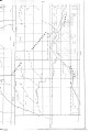
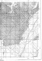
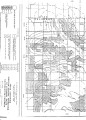
Show 67 classes of values. These five zones were plotted on the maps PV-225, 1-12 (see p i s . 14-25) and designated r e s p e c t i vely Zones 1, 2, 3, 4 and 5. Zone 1 embraces the area which extends for a d i s t a n c e of 1,500 feet from the outcrop of the lowest vanadium-bearing . sandstone or the area where the vanadium-bearing sandstones exist without substantial cover or over-burden at a g r e a t e r d i s t a n c e from the outcrop than 1,500 f e e t . Zones 2, 3 and 4 embrace successive b e l t s, each 1,500 feet in width, extending from the adjacent limit of the neighboring zone nearer the outcrop. Zone 5 contains the remaining portion of the vanadium-bearing lands not included In Zones .1-4 i n c l u s i v e . The area of the subject lands within each of these zones was determined by use of planimeter to be as follows: Zone 1 98,635 acres Zone 2 58,720 acres Zone 3 40,903 acres Zone 4 32,061 acres Zone 5 95.371 acres Total area vanadium-bearing subject lands 325,690 acres T^r.!rminflf,mn of Market Value. Collection of Sales Data. The second step In the utilization of sales data for determination of the market value of the vanadium-bearing subject lands of the Southwestern Colorado area was to collect and analyze all available sales data for vanadium-bearing properties in the Southwestern Colorado area sold |