| Title |
Annual Report of the Commissioner of Indian Affairs - 1900 (Pt I) |
| Subject |
Indian reservations; Federal government; Indians of North America; Indians of North America--Education; Courts; Allotment of land; Land use; Railroads; Timber; White people--Relations with Indians; Health; Annuities; Horses; Crime; Missionaries; Irrigation; Grazing; Livestock; Natural resources; Education; Water rights; Tribal government; Religion; Indigenous peoples--North America |
| Keywords |
Annual Report; Indian Agency; Reservations; Tribal Funds; Allotment; Land Rights; Resources; Mining; Native Americans |
| Publisher |
Digitized by J. Willard Marriott Library, University of Utah |
| Tribe |
Ute |
| Language |
eng |
| Description |
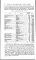
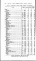
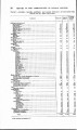
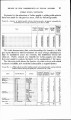
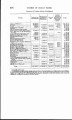
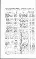
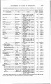
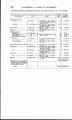
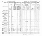
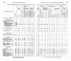
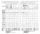
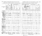
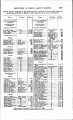
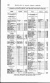
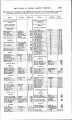
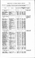
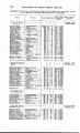
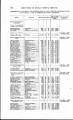
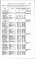
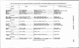
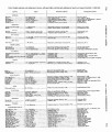
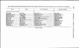
Excerpts concerning Utah from the Annual Report of the Commissioner of Indian Affairs - Courtesy of the University of Wisconsin Digital Collections. The Commissioner of Indian Affairs submits a report outlining issues such as Indian finances, the distribution of allotments, progress and enrollment in Indian schools, irrigation and agriculture projects, and the construction and maintenance of railroads across Indian land. The Uintah Ouray Reservation agent describes the location and condition of the reservation, demographic data, marriage practices, educational policy, progress in farming, the sale of liquor, and his recommendations for the reservation/agency |
| Type |
Text |
| Coverage |
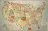
Uintah and Ouray Indian Reservation (Utah); Utah; Washington (D.C.) |
| Format |
application/pdf |
| Rights |
Digital Image © 2011 America West Center. All Rights Reserved |
| ARK |
ark:/87278/s6zg9nwz |
| Creator |
Commissioner of Indian Affairs; Jones, William A.; Myton, H.P. |
| Date |
1900 |
| Spatial Coverage |
Uintah and Ouray Indian Reservation (Utah); Utah; Washington (D.C.) |
| Setname |
uaida_main |
| ID |
373453 |
| Reference URL |
https://collections.lib.utah.edu/ark:/87278/s6zg9nwz |