OCR Text |
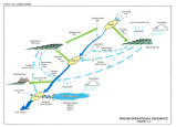
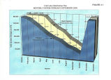
Show Final Report Hydrologic Model Analysis of the Provo River Basin consist of unconsolidated valley- fill and alluvial fan deposits ranging from less than 100 to more than 400 feet thick. The maximum elevations in the study area exceed 10,000 feet. The lowest elevation, where the Provo River enters Utah Lake, is about 4,500 feet. Precipitation and temperature in the area vary with elevation. The average precipitation in the area ranges from about 12 inches annually near Utah Lake, to about 16 inches annually in the Heber Valley to more than 40 inches annually in the mountains. Most precipitation falls as snow, primarily from October through April. Monthly average maximum temperatures along the eastern shore of Utah Lake range from 37° F in January to 93° F in July; monthly average minimum temperature range from 19° F in January to 60° F in July. Monthly average maximum temperatures in Heber Valley range from 34° F in January to 87° F in July; monthly average minimum temperatures range from 8° F in January to 48° F in July. Temperature in the mountains varies widely as a function of both elevation and exposure. Summer maximum temperatures may reach the low- to mid- 70' s, while winter minimum temperatures ranging several degrees below 0° F are common. Streamflow in the study area is derived primarily from mountain snowmelt, although some streams originate in lower elevation springs and seeps along the edges and within the centers of the valleys. The timing and magnitude of flows on the Provo River are significantly altered from their natural pattern because of transbasin diversions into the Provo River from the Duchesne Tunnel and Weber- Provo Canal, irrigation diversions and return flows in the Heber Valley and Utah County, and municipal and industrial diversions out of the basin between Deer Creek Reservoir and the City of Provo. The aforementioned elements, plus the delivery of transbasin diversions from Strawberry Reservoir and the operation of Deer Creek and Jordanelle reservoirs, all significantly alter the flows into and out of Utah Lake, the downstream boundary of the study area. The study area includes all or part of five major water supply projects constructed by United States Bureau of Reclamation ( USBR) or by others. In order of completion these are: the Head of River Reservoirs ( HOR) consisting of 15 small lakes at the headwaters of the Provo basin, operated by the Provo Reservoir Water Users Company and others; the Weber River Project ( WRP), operated by the Weber River Water Users Association; the Provo River Project ( PRP), operated by the Provo River Water Users Association ( PRWUA); the Weber Basin Project, operated by the Weber Basin Water Conservancy District; and the Central Utah Project ( CUP), operated by CUWCD. WRP includes Echo Reservoir and other facilities. PRP includes Deer Creek Reservoir and the Weber- Provo Diversion Canal. The Weber Basin Project includes Wanship and East Canyon Reservoirs and other facilities. CUP includes Jordanelle Reservoir, the rehabilitated Trial, Washington, and Lost lakes, and other facilities. January 1998 Page 4 |