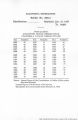
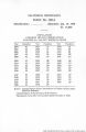
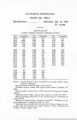
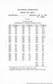
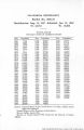
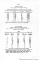
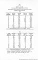
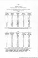
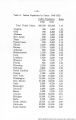
| OCR Text |
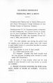
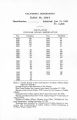
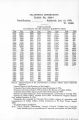
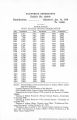
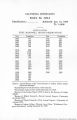
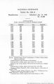
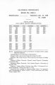
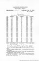
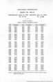
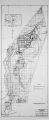
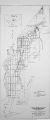
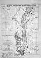
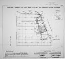
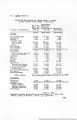
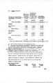
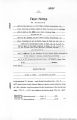
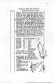
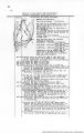
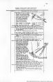
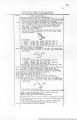
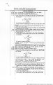
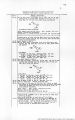
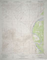
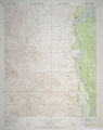
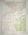
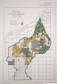
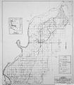
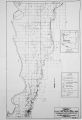
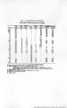
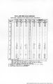
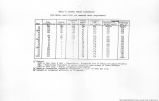
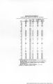
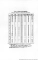
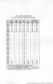
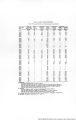
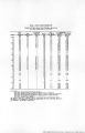
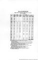
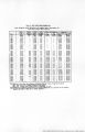
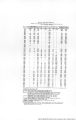
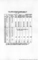
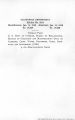
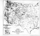
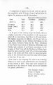
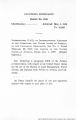
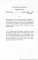
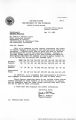
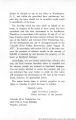
Show CERTIFICATE OF UNITED STATES SURVEYOR. I, .Sidney E. Blout._. U-S-Cadastral Engineer, hereby certify upon honor that, in pursuance of special instructions received from the District Cadastral Engineer,for ..Group 149 Arizona........ bearing date of the .....7th..........day of......January..........., 1928 , I have well, faithfully, and truly in my own proper person, and in strict conformity with said instructions, the Manual of Surveying Instructions, and the laws of the United States, retraced all those parts or portions of....................................... the Boundary of Fort Mohave Indian Reservation and the U.S. Coast and Geodetic Survey .Oblique., Boundary. Line of California and Nevada............................. resurveyed all those parts or portions of............................................................................................. the Boudary of Fort Mohave Indian Reservation and Arizona, and surveyed all those parts or portion* of the Boundary of Fort Mohave.-/ric/{an..fosmivAjfj2T^*i!a(-. ................................... Tie between the former and the Present California-Nevada State Boundaries ............................ . . .............................................., which are represented in and by diagram on page 1 hereof the foregoing field notes/as having been executed by me, and under my direction; and that all the corners of said retracement, resurvey and survey have been established and perpetuated in strict accordance with the Manual of Surveying Instructions, and the special written instructions of the District Cadastral Engineer ifor Group 149, Arizona.. and in the specific manner described in the field notes, and that the foregoing are the original field notes of such retracement, resurvey and survey Sidney E. Blout U.S. Cadastral Engineer. The foregoing field notes of the retracement of......................................................__................. Part of the Boundary of the Ft.Mohuve Indian Reservation, and Part Of the U.S. Coast & Geodetic Survey Oblique Boundary Line of........................ California and Nevada. of.-.the-..resurvey .of Part of the Boundary of the Ft.Mohave Indian Reservation, and Port .of the Subdivision lines and north edge of.Frac. T. 18..ii»,P.^22..a-.-.o£..... t>-e G.4 S.?.. 5.4.11.. Arizona. .•r)s}.-.<?f.-^-'>*--'*y.ry«Y..9.r. yart of the lO'Uutfcr? of the Ft.Hohavo Indi< p Pearrvatior i.rd a Tie .bfi.tW.een..tiie..J:Former and present Calif-Nevada -State...3muatlax.iea............. executed by Sidney. E. Blout Cadastral Engineer under his special instructions dated January 7, 1928 for GroupJ.4.?l«»»1* , having been critically examined, and the necessary corrections and explanations made, the sHid field notes, and the retrace- mtnt*. ni»urv«y« »nd survtyj ^they describe, are hereby approved. >>»•" A Office of U. S. Supe»visor or Surveys, Dfir.y.f!-r.,...Cplp.. ,_..No.YAmi>Ar..l5- , 1930. APPROVAL.. |
| Source |
Original book: [State of Arizona, complainant v. State of California, Palo Verde Irrigation District, Coachella Valley County Water District, Metropolitan Water District of Southern California, City of Los Angeles, California, City of San Diego, California, and County of San Diego, California, defendants, United States of America, State of Nevada, State of New Mexico, State of Utah, interveners] : |