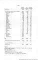
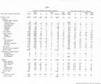
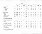
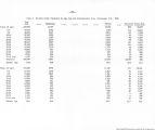
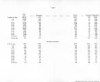
| OCR Text |
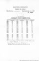
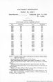
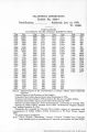
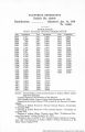
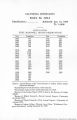
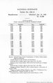
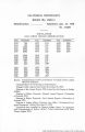
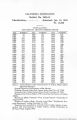
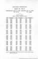
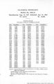
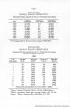
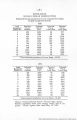
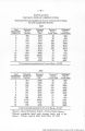
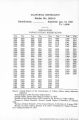
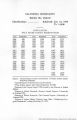
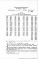
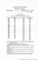
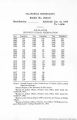
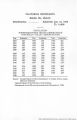
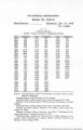
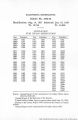
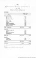
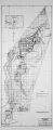
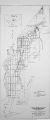
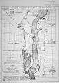
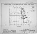
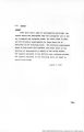
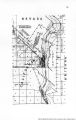
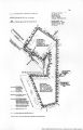
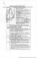
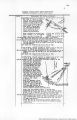
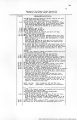
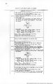
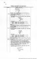
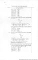
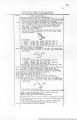
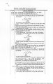
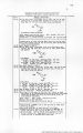
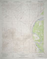
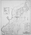
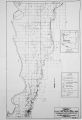
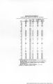
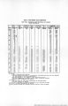
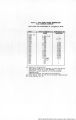
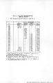
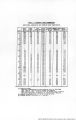
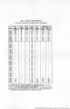
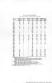
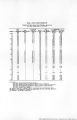
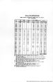
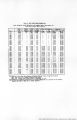
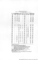
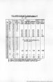
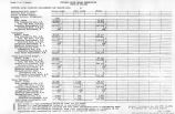
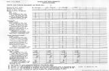
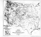
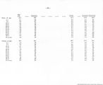
Show Boundary of Fort Mohave Indian Reservation (Formerly Camp Mohave Indian Reservation) chains 7.31 BeBurvey continued. Intersect the Bast Side Center Monument, which ie a decayed mesquite post, about 4 Ins. square, projecting 6 Ins.above ground, firmly set, marking obliterated, and witnessed by stump of one of the two original mesquite bearing trees, which bears S.45"4°W. 27 Iks. dist. from the post, No trace of the original NW. bearing tree can be found. Reconstruct this mon. aa follows; alongside old mesquite post. Bet an iron post, 3 ft. long, 2 ins. dia.,26 ins.in the ground, for East bide Center Monument of the Ft.Mohave Indian Reservation boundary, with brass cap marked 2 3 C T 18 H S 3 R 22 W I I 1C28 from whioh • willow, 8 ins. dia., bears N.77$°w., 166 Iks. dist., marked B S C FMIR BT S3. oor. of house, bearB N.37f"W., 139 lks. diat. U.S.G.S. Bench Mark, Elev. 488 ft., in headgate of Colorado Irrigation Co. Canal, bears N.56° 9'W. 10.68 ohe. diet. , level. Soil, sandy, 1st and 2nd rate. Timber, mesquite, willow and cottonwood. Undergrowth, arrow-weed and scrub mesquite. RESURVEY of Part of the North Boundary of Fractional Township 18 North, Range 22 West Gila & Salt River Base A Meridian, Arizona 2.71 The north bdy. of Frac. T.l8 N..R.22 W..Ariz. was surveys in 1873 by O.H.Case U.S.D.S. ,with a due Vest course and a distance of 363.00 chs. from NE.cor.of said Tp. to point of intersection with the east line of the bdy. of the old way and Wood' Reservation of the Camp Mojave Military Reserv. No retracement or resurvey of this township boundary was executed until 1905. when J.J. Fisher, U.S.D.S. made an independent resurvey of the entire line, recording a due west course and a length of 202.71 chs. A cocrpariwon of records of the survey and resurvey of the Tp. bdy. shows that the latter was executed in a position approximately one half mile north and two railos west from the former. Bo retraoement or re8ur/ey.subsequent to the Fisher resurvey. Is of record. The following notes describe a reaurvey of that portion of the line between the ^ sec.oor.of secs.3 and 34, and the Tp. dosing cor. of the P.M. I.R. Bdj . Retraoement for Hesurvej. From point of original locution of the reestablished i sec.oor.of secs.7! and 34, West,on rundon line,bet. aeua.3 and ^4. Interaoct the reestablished closing cor.of Prac.Ts.l6 and 19'.N.,R.22 W. ,on the bd;-. of Ft.Hohave Indii-n ReBorv. True oourso and dist. of the portion of the II. bdy.of |
| Source |
Original book: [State of Arizona, complainant v. State of California, Palo Verde Irrigation District, Coachella Valley County Water District, Metropolitan Water District of Southern California, City of Los Angeles, California, City of San Diego, California, and County of San Diego, California, defendants, United States of America, State of Nevada, State of New Mexico, State of Utah, interveners] : |