OCR Text |
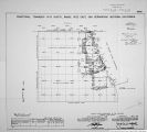
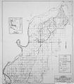
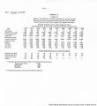
Show Boundary of Fort Mohave Indian Reservation ( formerly Camp Mohave Indian Reservation) Survey of completion of .Boundary of Port Mohave Indian Reserv. to Include the areas hereinbefore described as comprising said reservation at the present time Resurvey of part of the north bdy. and part of the subdivision lines of Frac.T.l? '., C* S.K. B.AM..Ariz. Retracement of part of the present NEV.-CALIF. State Boundary line (U.S.Coast A CeodeticSurvey Iiine Survey of a 113 between the old and the pre.ent ..EV.- C^LiI?. State Boundary Aries. In addition to descriptions of ail Indian Reserv.°d,y. monuments, found, reconstucted, reestablished, or established in these resurveys .retracements and surveys these notes include descriptions of all of the Fisher closing cors;. found, reconstructed or reestablished, also closing cors. established on the Reserv.3d;7. at points of intersection with 2nd .'tandarii parallel H. of the oar Bernardino Base Xiine,Calif.-, and with the present state Boundary jice Bet. NEV. and CALIFa a retracement of the Bdy. of old Camp Mojave :Mil. Reserv.; and of the south and north lines of the ?dy. of the old nay ~nd Wood Reserv..executed nreiimipary to the resurfey and survey of the F.H.I.B. 3dy. herein described, failf-eti to reveal any evidence of Cors.Noe.2,? * 4 of the Mil. Reserv. , or of Cors. IIos.? A 4 of the hay and Wood Reserv. , therefore .the record bearinfs and distances ere used in the survey of such portions of the Bdy. off ?."I.I.R. as are intended to be identical nith the i3dy.' of the oLd Ca^np Hojave i:il.Resr>rv. , and the record beuri: ;?s oniy are used in the survey of the portions ; intended to be identical, with parts of the south and north lines of the Be1;;, of the old Kay and 'ood Reserv. _'he V(»>st line of -d; . of o-id uay and 'ood Reterv. accord-11:a to record.was between Cors.IIos.^ A 4, both of which were located on the east bank of the Colo.River. As all trace of aid river bank as it existed in l869 has now dissappeared, the original position of said west line of old Hay and; Wood Reserv. is restored for purpose of survey of Bay.Of ?.:i. I.R. by reference to points where the random south and north lines of said old Reserv. intersect a well defined •bank, which mu;st have been the west or right bank of the Colo.River in the year l:Lr. ^ "lore detailed explanation of the restoration of the said west line of the old Reserv. is hereinafter described in notes of "Retracement for After the west lino of old iiay and Wood Reserv. is restor ed to approximately its? original positioin, the 3dy.of ?.".I.":. is surveyed r.ort)\Ke8terly tl:oreon to original, no.-iition of Cor.Ho.4 Bhere Cor.I.'o.4 of icy.of P.r.I.l-'.l is established. Whence n..jterly axoi e north line of oid jay and ood Keserv. to its noitt of intersection with the present east or left bank of Colorado r.iver.which TOii.'t ie now tieoig- Thei ce northerly along said east bank of Colo.River to its point of intersection with the sa. line (1-2; of Pdy.of , old Camp Mojave .'AL .Reser". .which point is now desigr- nated and monnonted as :or.iio.t of Bdy.of I'.".1.1 . so ith'ieuteily on S"5.Lined-2J of o.O . ii.hoserv. to ¦>olrt : or Cor.Ho.2 thereof, now in Coio. River ard designated as ;or..iO.7 of 3<3y. of '..".I.R. north- esterly on S' ¦. line ( 2-3) of old Hil.Reserv..to point for '.Jor».fo»3 thereof, now aotl'i'v *ed ard morunent-od as Cor.No.3 of Bdy.of r.'T. I.h. |
Source |
Original book: [State of Arizona, complainant v. State of California, Palo Verde Irrigation District, Coachella Valley County Water District, Metropolitan Water District of Southern California, City of Los Angeles, California, City of San Diego, California, and County of San Diego, California, defendants, United States of America, State of Nevada, State of New Mexico, State of Utah, interveners] : |