| OCR Text |
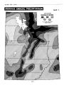
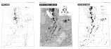
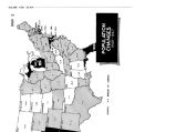
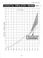
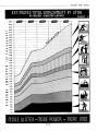
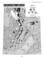
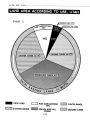
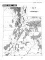
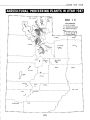
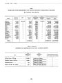
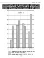
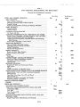
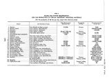
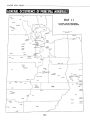
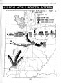
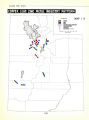
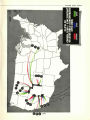
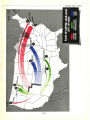
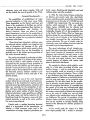
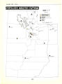
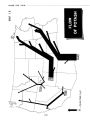
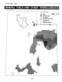
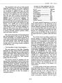
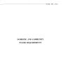
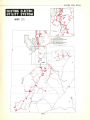
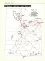
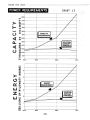
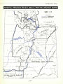
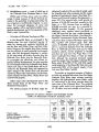
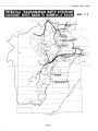
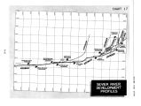
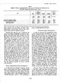
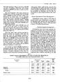
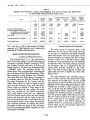
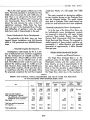
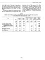
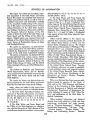
Show WATER FOR UTAH This Is the most sparsely settled area in the State. The total population is probably less than 9,000, about one person for each 1,350 acres of land. There is no railroad into the heart of the area, although the northern part is traversed by one. Consequently, there is little industry and almost the only demand for water is that for agricultural purposes. While there has been plenty of water in the Colorado River, the physical difficulties of getting it onto the arable lands have made it impracticable in the past. .. Present Hydroelectric Power Development The potentials of this Basin have not been tapped. Present installations total 220 kilowatts which in 1945 generated some 800,000 kilowatt- hours. ... Potential Irrigation Development... Investigations made largely by the U. S. Bureau of Reclamation have resulted in suggestions for the development of 216,000 acre- feet of additional water. All but 8,800 acre- feet of this is proposed for use on 102,300 acres of fiew land. The 8,800 acre- feet would be used to supplement the existing supply on 16,200 acres of land. However, there would still be 25,500 acres of land which would be 15,100 acre- feet short, or would have only 78% of a full supply. Were the proposals completed, the land then irrigated would have 95.2% of a full supply. ( See Table 18.) The major proposal for developing additional water involves storage on the Colorado River near the Colorado border. This would irrigate some land in Colorado. Other small storage reservoirs on small tributaries have been proposed. . Potential Hydroelectric Power Developments .. As in the case of the Green River Basin, major hydroelectric power development projects are proposed in conjunction with major storage reservoirs. These include Dewey, Moab, Dark Canyon, Bluff, Goosenecks, Slick Horn Canyon, Great Bend and Glen Canyon. The proposed installed capacity of these projects would be approximately I. I million kilowatts with potential generation of approximately 6 billion kilowatt- hours per year. VIRGIN RIVER DRAINAGE BASIN ... Location and Physical Features ... The Virgin River Drainage Basin is in the southwest corner of the State. It includes only Washington County and the western part of Kane County, an area of approximately 2 million acres. Much of this area is unique in the State in that the elevation is about 2,000 feet lower than any other area. The major stream is the Virgin River which rises in the mountains to TABLE 18 PRESENT AND POTENTIAL ANNUAL REQUIREMENTS AND USE OF WATER FOR IRRIGATION IN THE COLORADO RIVER DRAINAGE BASIN, UTAH Area Required for Full Supply Present Water Supply Additional Water Planned Shortage After Proposed Development Adequacy of Supply After Development rtem Within Basin Colorado Basin Land now fully irrigated. 1,000 acres 4.2 25.5 16.2 102.3 148.2 260.2 1,000 A.- Ft. 8.0 68.3 28.0 207.2 311.5 546.4 1,000 A.- FK 8.0 53.2 19.2 80.4 80.4 1,000 A.- FK 1,000 A.- R. 8.8 207.2 216.0 216.0 1,000 A.- Ft. 15.1 15.1 250.0 Per cent 100.0 Land inadequately irrigated: No additional water proposed . Additional water proposed New lands 77.9 100.0 100.0 Total now used and proposed for irrigation 95.2 Total arable land 54.2 [ 121] |