| OCR Text |
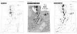
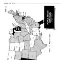
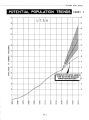
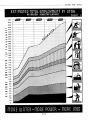
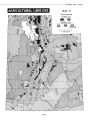
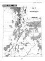
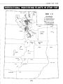
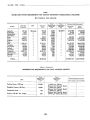
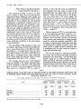
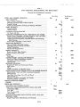
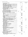
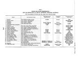
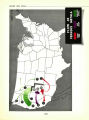
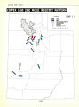
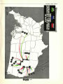
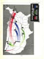
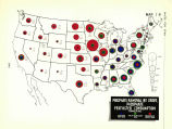
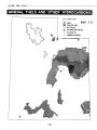
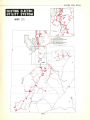
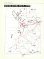
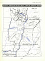
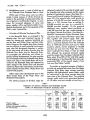
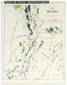
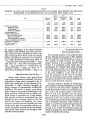
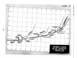
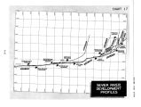
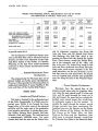
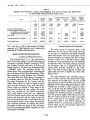
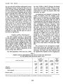
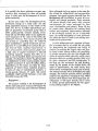
Show WATER FOR UTAH TABLE 10 PRESENT AND PROPOSED ANNUAL REQUIREMENTS AND USE OF WATER FOR IRRIGATION IN THE BEAR RIVER BASIN, UTAH Item Area Required for Full Supply Present Water Supply Additional Water Planned Shortage After Planned Development Within Basin Colorado Basin 1,000 acres 1,000 A.- Ft. 1,000 A.- Ft. 1,000 A.- Ft. 1,000 A.- Ft. 1,000 A.- Ft. 77.0 276.0 276.0 113.0 50.0 185.0 319.0 140.0 748.0 209.0 100.0 40.0 338.0 410.0 110.0 425.0 1,483.0 585.0 378.0 410.0 110.0 532.2 1,862.7 585.0 378.0 410.0 489.7 Adequacy of Supply After Development Land with adequate supply Land with inadequate supply: No additional water proposed Additional water proposed New lands Total used and proposed for irrigation Total arable land Per cent 100.0 65.5 100.0 100.0 92.6 73.7 to provide water for it. The development of additional storage reservoirs on the Bear River and its tributaries and the diversion of water from tributaries of the Colorado River System in the Vicinity of Cokeville, Wyoming to the Bear River would necessitate reservoirs on these streams and diversion tunnels and canals. ... Potential Hydroelectric Power Developments... The proposed plan for this basin does not at present include any further power development. However, it does provide for interconnections to enable joint operations of power facilities in this basin and those of the Central Utah Project. WEBER RIVER ,.. Location and Physical Features ... This basin is located in the northcentral part of the State. Economically, it is Utah's most important area. Within it are located the three largest cities of the state, most of the industrial activities and the major part of the production from irrigation agriculture. It includes these counties: Weber, Morgan, Davis, Summit, Salt Lake, Wasatch, Utah and Tooele. The total land area is approximately 9,000,000 acres. The major streams that drain the area are the Weber River and its tributaries, emptying into Great Salt Lake; the Provo and the Spanish Fork Rivers that discharge into Utah Lake, which in turn empties into Great Salt Lake through the Jordan River. These streams, except the Jordan River, rise in the mountains east of the valley and flow to the west. The Jordan River heads in Utah Lake and flows northward into Great Salt Lake. Many other small streams originate in the Wasatch Mountains, but the area drained is so limited that many are only intermittent. The largest area of irrigated land, and the most productive area, lies along the base of the Wasatch Mountains. ... Present Irrigation Development... Diversions from the natural flow of the streams provide some water for irrigation. However, since the peak natural runoff is in May and June, and the peak demands for water are in July and August, the areas that are entirely dependent upon natural stream flow usually have an inadequate supply in the late summer. To equalize the supply through the summer, several storage reservoirs have been constructed. The important ones are: the Pineview on the Ogden River ( a tributary of the Weber), the Echo and East Canyon on the Weber River, the Deer Creek on the Provo and the Strawberry from which water is conveyed through a tunnel from the Colorado River Basin to the Bonneville Basin. [ 114] |