| OCR Text |
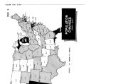
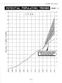
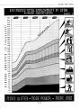
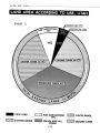
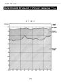
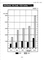
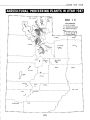
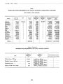
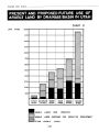
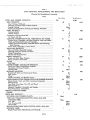
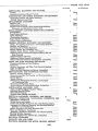
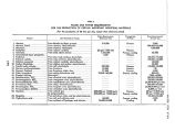
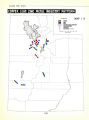
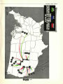
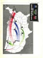
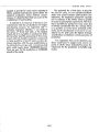
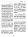
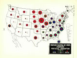
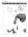
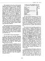
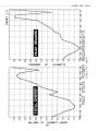
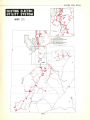
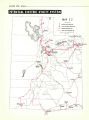
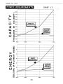
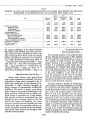
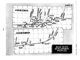
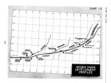
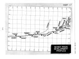
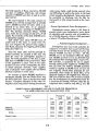
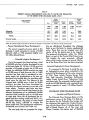
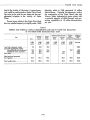
Show WATER FOR UTAH TABLE 8 SUMMARY OF LAND AREA NOW IRRIGATED ( EXCLUSIVE OF PASTURE) AND PROPOSED FOR IRRIGATION DEVELOPMENT IN THE BONNEVILLE AND THE COLORADO RIVER BASINS, UTAH Item Bonneville Basin Upper Colorado River Basin Total Colorado and Bonneville Basins Virgin River Basin State Total Land now irrigated: Adequate supply Partial supply Total now irrigated Land proposed for irrigation development: Now has partial supply Not now irrigated... Total proposed to irrigate.-. Total now irrigated and new land proposed for irrigation Per cent increase in irrigated acres 1,000 acres 338.3 429.2 767.5 237.5 350.8 588.3 1,118.3 46.0 1,000 acres 66.0 167.1 233.1 161.1 243.6 404.7 476.7 105.0 1,000 acres 404.3 596.3 1,000.6 398.6 594.4 993.0 1,595.0 59.0 1,000 acres 3.5 15.4 18.9 8.2 13.0 21.2 31.9 69.0 1,000 acres 407.7 611.7 1,019.4 406.8 607.4 1,014.2 1,626.9 60.0 the compact obligation of the Upper Colorado River Basin states. Without three main stem storage reservoirs, further utilization of water in the Upper Colorado River Basin would be seriously limited and definitely restricted as to maximum most widely distributed benefits. ( See Chart 14 - Colorado River Development Profiles - page 108; Chart 15 - Bear River Development Profiles - page 109; Chart 16 - Weber River De velopment Profiles - page I 10; Chart 17 - Sevier River Development Profiles - page III.) ... Hydroelectricity Pays the Way ... Stored water, flowing water and diverted water means hydroelectric potentials. The many hydroelectric power plants envisaged in the ultimate plan would have a total capacity of approximately 2 million kilowatts, providing an energy resource of approximately 6 billion kilowatt- hours. This source of power, some eleven times as great as the present development in the State, would be collected from its widely scattered sources of generation by a high voltage- high capacity network of transmission lines, and brought to major consuming centers for sale. The sale of this energy will constitute the major source of revenues required to liquidate the costs of the entire plan of construction and the operation of projects required for the full development of the water resources of the Upper Colorado River Drainage Basin. ... The Potential Over- All Plan in its Major Details ... The principal portions of the potential plan all have differing characteristics in their methods of water collection and distribution, as well as in their outlook of major benefits. The principal project involved is the so- called Central Utah Project. It is considered as the master plan of development for Central Utah which includes the Uintah Basin and the area immediately west of the Wasatch Mountains from Salt Lake City on the north to Fillmore on the south. It represents the culmination of 29 years of investigations and planning by federal, state and local organizations, directed to the ultimate utilization of the area's land and water resources. The plan involves a transfer of Uintah Basin water supplies to the Bonneville Basin in exchange for water from the Green River. Supplying the Uintah Basin lands involves the construction of a dam, power and pumping plants on the Green River, as well as an aqueduct from the Green River to Duchesne, Utah. Runoff from the Uintah Mountains as far east as Brush Creek would be conveyed through a series of short collection tunnels to Strawberry Reservoir, which would be enlarged to provide the required storage capacity. Water would be released from the reservoir through a new tunnel into Diamond Creek and dropped through four power plants for the production of hydroelectric energy. [ 107] |