| OCR Text |
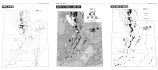
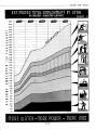
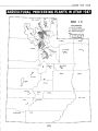
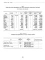
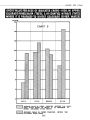
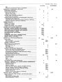
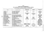
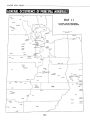
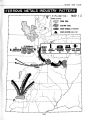
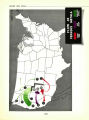
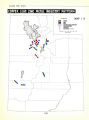
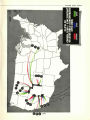
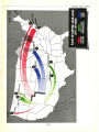
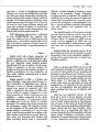
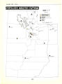
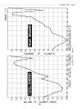
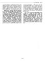
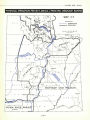
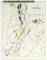
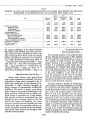
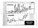
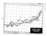
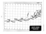
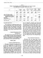
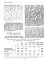
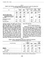
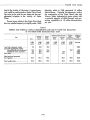
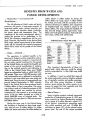
Show WATER FOR UTAH TABLE 14 PRESENT AND POTENTIAL ANNUAL REQUIREMENTS AND USE OF WATER FOR IRRIGATION IN THE SEVIER RIVER DRAINAGE BASIN. UTAH Area Required for Full Supply Present Water Supply Additional Water Planned Shortage After Proposed Development Adequacy of Supply After Development Item Within Basin Colorado Basin Land now fully irrigated 1,000 acres 36.0 148.9 69.1 81.3 335.3 1,169.3 1,000 A.- Ft. 119.0 568.8 243.1 328.0 1,258.9 4,384.9 1,000 A.- Ft. 119.0 436.5 147.0 702.5 702.5 1,000 A.- Ft. 3.9 3.9 3.9 1,000 A.- Ft. 92.2 328.0 420.2 420.2 1,000 A.- Ft. 132.3 132.3 3,258.3 Per cent 100.0 Land inadequately irrigated: No additional water proposed.. Additional water proposed New lands 76.7 100.0 100.0 Total proposed for irrigation 89 5 Total arable land 25.7 No. I and No. 2, with a total proposed installed capacity of 17,500 kilowatts and a generating potential of 70 million kilowatt- hours. GREEN RIVER DRAINAGE BASIN ... Location and Physical Features - This drainage basin is in the northeastern part of the state adjacent to both Wyoming and Colorado. It includes Daggett, Duchesne, Uintah and Carbon Counties and parts of Emery and Grand Counties. The total area is approximately I 1,000,000 acres. The principal stream, the Green River, rises in southwestern Wyoming and the north slope of the Uintah Mountains in Utah, flows eastward a short distance into Colorado, then turns back into Utah where it proceeds in a southerly course to join the Colorado River. The major tributaries are the Yampa and the White Rivers which rise and are largely in Colorado and the Duchesne, Price, and San Rafael Rivers, which are entirely in Utah. Most of the farm land lies along the river valleys. The major' land area consists of the Uintah Mountains, high, rough plateau lands that are adaptable only for livestock grazing. Since the land is badly broken and dissected and the major stream follows the lowest levels and is much below the adjacent plateau lands in many cases, the physical and economic problems of utilizing the potential supply of water are great. In fact, the problems are seemingly beyond the capacity of local communities to handle. ... Present Irrigation Development... The major source of irrigation water is the tributaries, not the Green River itself. The largest acreage is in Duchesne and Uintah Counties where the streams from the south slope of the Uintah Mountains are utilized. The flow of these streams is often low in the late summer. Some storage has been developed, but not sufficient to meet the needs. The major storage reservoirs are the Moon Lake on a tributary of the Duchesne River and the Scofield on the Price River. The total storage capacity of these and other small reservoirs is slightly more than 100,- 000 acre- feet. The total irrigated land, including pasture, most of which receives only flood water irrigation, amounts to 231,900 acres. Of this, 61,700 acres situated on the Price River and in the Uintah Basin receive full or adequate irrigation, while 170,200 are normally in short supply by about 16%. In all the area the existing supply of water is approximately 88.8% adequate for the land irrigated. The shortage amounts to 45,600 acre- feet. The present supply is 454,100 acre- feet less than the amount required to irrigate adequately al! the arable land in the drainage basin. Thus, the present supply is only 44.4% adequate. In addition, there is a considerable acreage of class 4 land, which can be economically irrigated for pasture. ( See Table 15.) [ 118] |