| OCR Text |
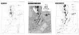
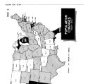
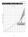
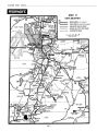
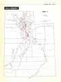
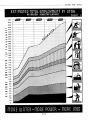
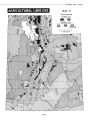
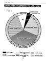
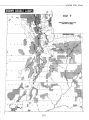
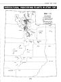
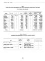
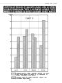
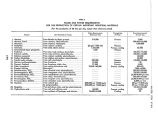
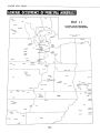
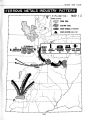
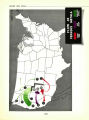
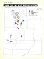
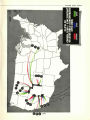
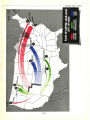
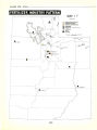
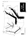
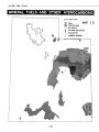
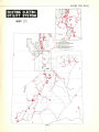
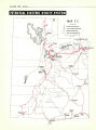
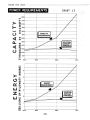
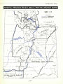
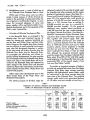
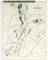
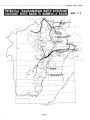
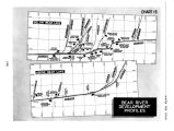
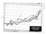
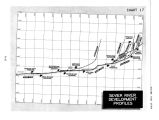
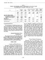
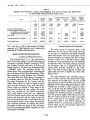
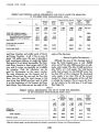
Show WATER FOR UTAH 5. Miscellaneous areas - most of which are in the Colorado River Drainage Basin in Utah. Within each of these areas, water use will be varied. In large measure, it will be directed primarily to the potentials of arable land either not now irrigated or insufficiently irrigated. In some areas, the increased adequacy of water and power supplies will be particularly helpful to industrial development and to the expansion of the State's major communities. . . . Principles of Ultimate Development Plan . . . In the Bonneville Basin, as envisaged in the ultimate plan, the most important sources of water for storage and maximum beneficial use are the Bear and Weber Rivers and their tributaries. However, the supplies from these streams are not sufficient to meet potential requirements even when fully developed; therefore, a portion of the total needs will involve diversion from the Colorado River Basin into the Bonneville Basin. To accomplish this effectively and without impairing existing developments, the plan provides for interchanges within the Colorado River Basin; waters now used in the Uintah Basin will be diverted to the Bonneville Basin and replaced by water stored in the Green River and diverted westward.. These water transactions and developments embody the Bear River, Weber River and Central Utah projects. Other major water development areas in the State involve those of the Virgin River and Southeast Utah projects. The primary purpose of all these major development projects is the securing of ample water for irrigation and other purposes and the copro- duction of hydroelectric power. ( See Map 24 - Present and Potential Irrigation Developments - page 105.) The potential plan would provide an increase of 2,163,400 acre- feet annually for the State, or a 75% increase from an existing 2,- 875,400 acre- feet per year to a potential 5,- 038,800 acre- feet annually. Of the proposed additional water supplies, about two- thirds, or 1,441,200 acre- feet per year, would originate in the Upper Colorado River Basin. ( See Map 25- Potential Transmountain Water Diversions Colorado River Basin to Bonneville Basin- page 106.) This, together with present supply from that source of 552,900 acre- feet per year would result in a potential depletion from the Colorado River of 1,994,100 acre- feet each year to which should be added a further depletion of 101,300 acre- feet per year from the Virgin River in the Lower Colorado River Basin. It must be noted that, although the proposed increased supply would be largely from the Upper Colorado River Basin, about three- fifth of the total Utah supply would originate in the Bonneville Basin since approximately 80% of the present supply is from tnat area. ( See Tables 7 and 8.) To provide an important measure of balance to these net potential diversions from the Upper Colorado River Basin, large storage reservoirs together with hydroelectric power plants would be constructed in the deep canyons along the main stem of the Colorado River. The potential storage would assist in the guaranteed delivery of 7.5 million acre- feet annually at Lee Ferry - TABLE 7 SUMMARY OF ANNUAL PRESENT AND PROPOSED FUTURE SUPPLY OF IRRIGATION WATER BY SOURCES, UTAH Item Bonneville Basin Upper Colorado River Basin Total Colorado and Bonneville Basins Virgin River Basin State Total Present supply Proposed additions Present and proposed additions Per cent increase . 1,000 A.- Ft. 2,277.5 665.9 2,943.4 29.0 1,000 A.- Ft. 552.9 1,441.2 1,994.1 261.0 1,000 A.- Ft. 2,830.4 2,107.1 4,937.5 74.0 1,000 A.- Ft. 45.0 56.3 101.3 125.0 1,000 A.- Ft. 2,875.4 2,163.4 5,038.8 75.0 [ 104] |