| OCR Text |
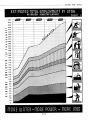
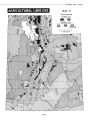
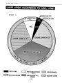
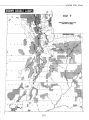
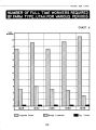
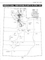
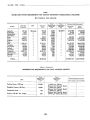
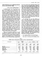
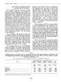
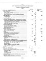
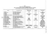
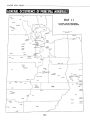
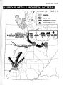
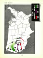
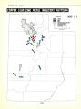
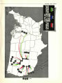
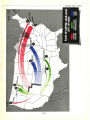
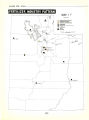
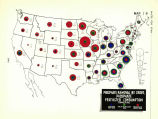
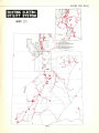
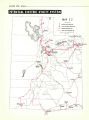
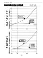
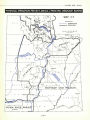
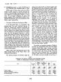
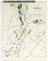
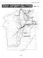
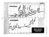
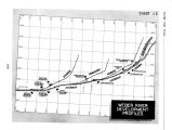
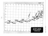
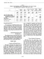
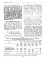
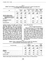
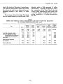
Show WATER FOR UTAH supply for the arable land. [ See Table 12). The new land that would be irrigated would be largely along the Wasatch Front, with the major acreage probably being in Weber, Salt Lake and Utah Counties. Some water could be used in Tooele County, where there is a large area of arable land. The lands to receive supplementary water are likewise widely scattered, with some concentration in southern Utah County. The proposals for developing the additional water include additional storage on the Weber River system and the transfer of additional water from the headwaters of streams tributary to the Green River in the Uintah Basin into the existing Strawberry Reservoir. . . . Potential Hydroelectric Power Plants . . . Major hydroelectric power developments are proposed for this basin. They include the power plants of the Central Utah Project, known as Diamond Creek Nos. I, la, 2, 3 and 4, and also those of Deer Creek, Provo River Extension, which would have a total installed capacity of 276,400 kilowatts with a generating potential of over one billion kilowatt- hours. SEVIER RIVER DRAINAGE BASIN ... Location and Physical Features ... The Sevier River Basin includes most of the southwestern quarter of the State. It includes Juab, Millard, Beaver, Iron, Sanpete, Sevier, Piute and the western part of Garfield County. The territory considered as part of the Sevier River Basin comprises an area of approximately 14,000,000 acres. The majority of the arable land lies in two long valleys running north and south, separated by a range of mountains. The Sevier River heads in the southeastern corner of the basin and flows northward through Garfield, Piute and Sevier Counties and much of Sanpete County, and into Juab County, then breaks through the mountain range westward, circles back and empties into Sevier Lake in Millard County. There is no other major stream in the basin, although there are many small streams, most of which become tributaries of the Sevier. The Beaver River drains a part of Beaver County and flows northward and joins the Sevier River north of Sevier Lake. However, due to diversions for irrigation uses, only occasionally does water from the Beaver River reach the Sevier River. The Sevier River and the small streams, many of which either dry up completely or nearly so during the late season, are the sources of irrigation water except for about 12,000 acre- feet which are diverted from the Upper Colorado River Drainage Basin and about 500 acre- feet diverted from the Virgin River Drainage Basin. The former amount comes into Sanpete County and the latter amount into the vicinity of New Harmony in Iron County. The natural stream flow is aided by several storage reservoirs. The Sevier TABLE 12 PRESENT AND PROPOSED ANNUAL REQUIREMENTS AND USE OF WATER FOR IRRIGATION IN THE WEBER RIVER- UTAH LAKE DRAINAGE BASIN, UTAH Area Required for Full Supply Present Water Supply Additional Water Planned Shortage After Proposed Development Adequacy of Supply After Development Item Within Basin Colorado Basin Land now fully irrigated 1,000 acres 225.3 26.1 118.4 84.5 454.3 694.4 1,000 A.- Ft. 735.0 98.0 447.0 267.0 1,547.0 2,361.0 1,000 A.- Ft. 735.0 65.0 300.0 1,100.0 1,100.0 1,000 A.- Ft. 97.0 187.0 284.0 284.0 1,000 A.- Ft. 50.0 80.0 130.0 130.0 1,000 A.- Ft. 33.0 33.0 847.0 Per cent 100.0 Land inadequately irrigated: No additional water proposed Additional water proposed New lands 66.3 100.0 100.0 Total proposed for irrigation 97.9 Total arable land 64.1 1Often the effective supply is less than this because the shortage is concentrated in the latter part of the growing season. [ 116] |