| OCR Text |
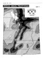
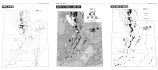
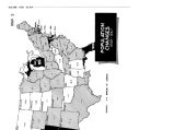
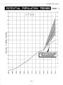
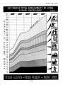
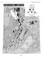
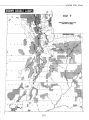
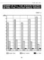
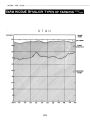
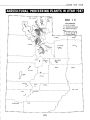
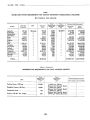
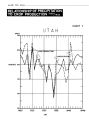
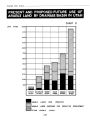
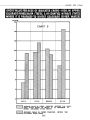
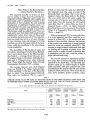
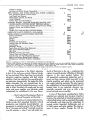
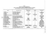
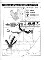
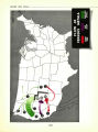
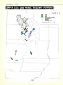
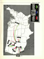
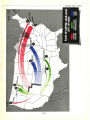
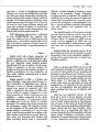
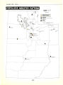
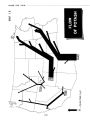
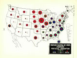
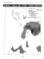
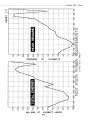
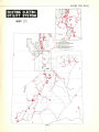
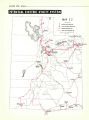
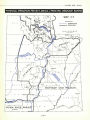
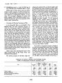
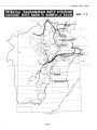
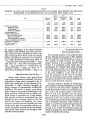
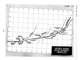
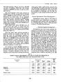
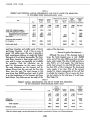
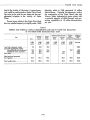
Show WATER FOR UTAH THE POTENTIALS OF AGRICULTURE IN UTAH CAN BE REACHED ... More Arable Land Than Water ... If sufficient water were economically available, the 3,176,000 acres of arable land in the State could be fully productive. However, the location of required water resources does not make this possible. Practically no additional water in Utah can be developed by direct diversion of natural stream flow resulting from rainfall and the melting of snows on high mountain peaks and slopes. The natural late- season flow - so necessary for the growing of crops to the harvesting point - was appropriated in all of Utah's streams years ago and is being fully used. ( See Chart 7 - j Relationship of Precipitation to Crop Production - page 28.) The high spring runoff not yet appropriated would be of little value without storage facilities to permit use later in the season. Therefore, new and necessary water will have to be impounded; much of it will be stored at distant points. In order to provide for increased water supplies, the major need is for numerous storage and control reservoirs, and for diversion works. ( See Table 2 - Present Use of Known Arable Lands by Drainage Basin.) Where soil and climate conditions are most favorable for agriculture in Utah, water is either not present at all or is so situated as to make its use on the land physically and economically impossible. The agricultural areas in the Bonneville Basin west of the Wasatch Range contain by far the most and the best agricultural lands of the State, with most favorable climatic conditions. However, the water supply within the basin, even when fully developed, is grossly insufficient to realize full acreage and production potentials. By comparison, the soils and climate of the areas east of the Wasatch Range and south of the Uintah Basin, in the Green and Colorado Basins, are less favorable and their water supplies, although more ample, are difficult of economic development. The waters of the Green and Colorado by transfers, exchanges and transbasin diversions can be utilized effectively in the Bonneville and Uintah Basins. It is obviously wise and most efficient to utilize water where greatest economic benefits can be realized. Therefore, potential water development in Utah must be directed to those areas which contain the best soils and are most favored by climate, transportation, community services and marketing facilities. On this basis, the lands in the Bonneville and Uintah Basins are those which possess the best potentials in the State and which provide the major opportunity for full agriculturaf development in Utah. Other areas, such as the Price River and San Rafael Drainage Basins, in somewftat lesser amount and degree will also make important contributions if properly developed. The development of the Virgin River area is also important. . . . But Additional Water Can Be Developed ... By means of storage and transbasin diver- TABLE 2 PRESENT USE OF THE KNOWN ARABLE LANDS BY DRAINAGE BASIN Irrigated Dry Farmed Not Used for Crops Drainage Basin Full Supply Partial Supply Total Total Arable Bear River 1,000 acres 77.0 225.3 36.0 61.7 4.2 3.5 407.7 1,000 acres 101.1 89.2 238.9 133.6 33.5 15.4 611.7 1,000 acres 178.1 314.5 274.9 195.3 37.7 18.9 1,019.4 1,000 acres 282.6% 93.0 101.3 0.9 33.2 6.0 517.0 1,000 acres 71.5 286.9 793.1 270.4 189.3 28.4 1,639.6 1,000 acres 532.2 Weber River- Utah Lake 694.4 Sevier River Green River.. Colorado River 1,169.3 466.6 260.2 Virgin River j 53.3 TOTAL .. , J 3,176.0 V ? [ 27] |