OCR Text |
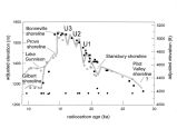
Show jJB* Utah Geological %# and Mineral Survey Public Information Series # 8 November 1990 The Utah Geological and Mineral Survey is a division within the Department of Natural Resources The Southern Pacific Railroad causeway was built in 1959 and breached in 1984.60% of the lake area is south of the Southern Pacific Railroad causeway, and the majority of fresh water enters the south half. The Great Salt Lake contains over 4.5 billion tons of salt. A million tons of salt per year were produced between 1980- 1986. Salt content of the lake varies from 9% to 28%. Early 1990 percentages: north half: 18% south half: 9% The oceans average 3%. The Great Salt Lake INFORMATION SHEET Great Salt Lake State Park SMarSMcfi Boa Harbor lake outline shown at 4200 feet elevation At least 10 knots of wind are required for 12 hours to create a major seiche wave. The pumping of Great Salt Lake water to the West Desert began in 1987 to alleviate flooding. 2.7 million acre- feet were pumped. Pumps were shut down on June 30,1989. The lake is the remnant of the freshwater Lake Bonneville which covered the valley between 10,000 to 30,000 years ago and left visible shorelines. Freshwater sources: Bear River, Weber River, Jordan River, Ogden River, springs and precipitation Resources: sodium chloride ( table salt), potassium and sodium sulfates, mag- nesium, chlorine gas, magnesium chloride brine, brine shrimp and eggs. For current level information call U. S. Geological Survey, Water Resources Division. Low levels on record: 1963 High levels on record: 1873,1986,1987 Surface elevation at low level: 4191.30 feet ( 1277.52 m) at high level: 4211.85 feet ( 1283.79 m) Volume minimum: 8.685 million acre feet ( 10.7 billion m3) maximum: 30.46 million acre feet ( 37.5 billion m3) Acres covered at low level: 610,200 acres ( 246,900 ha) ( in 1963) at high level: 1.472 million acres ( 595,700 ha) ( in 1986) Area covered at low level: 953 square miles ( 2470 km2) ( in 1963) at high level: 2300 square miles ( 5957 km2) ( 1870s and 1980s) Maximum depth at low level: 25 feet at high level: 45 feet Islands Approximate area Maximum elevation Antelope 23,175 acres 6596 ft. Badger 6 acres 4225 ft. Carrington 1767 acres 4727 ft. Cub - - Dolphin 60 acres 4275 ft. Egg - 4211 ft. Fremont 2945 acres 4995 ft. Gunnison 163 acres 4492 ft. Hat ( Bird) 22 acres 4275 ft. Stansbury 22,314 acres 6645 ft. |