OCR Text |
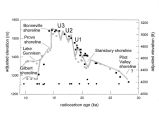
Show En route from Stop [ 2] to Stop [ 3]. The highest surveyed ( hydro- isostatically most rebounded) segment of Bonneville shoreline in the Bonneville basin is in this area, on the crest of the Lakeside Mountains ( to the east, on the uphill side of the graded road). Homestead Cave is between the Stansbury shoreline and Provo shoreline in the hills to the west, on the downhill side of the graded road. Stop [ 3], The purpose of this stop is to provide a vantage point for discussing many aspects of Bonneville basin aquatic system history. Jack Oviatt, whose documentation starts on the next page, will lead our discussion of basin- wide perspectives on Lake Bonneville. ( Hovingh on aquatic fauna of the Great Salt Lake Desert subbasin) Were the aquatic fauna uniformly distributed throughout the area occupied by Lake Bonneville? What mollusks and leeches lived in Lake Bonneville? Can one distinguish spring fauna associated with sites above the Bonneville shoreline from lake fauna? The mussel Margaritifera falcata is associated with the Bear, Weber, and Provo rivers, and requires salmonid fishes for its life cycle. Does the absence of Margaritifera in the western Bonneville subbasins suggest that the Bonneville cutthroat trout Salmo clarki did not occupy the entire lake? The mussel Anodonta californiensis is found throughout the Bonneville basin and requires Utah chub or the speckled dace for its life cycle. ( Hovingh on gastropods at Homestead Cave) The gastropods at Homestead Cave consist of abundant numbers of Pyrgulopsis ( called Amnicola in geological and early biological literature) and Stagnicola bonnevillensis. Did these gastropods live in Lake Bonneville, or were they associated with springs that fed into Lake Bonneville? Today, Pyrgulopsis is associated with springs throughout the Great Basin. What are the distributions of fish, mollusks, and leeches in the historic Great Lakes, prior to lamprey introductions? The leeches may only occur in association with river outlets. The gastropod Lymnaea stagnalis occurs in quiet bays of Lake Superior. What were the environments in Lake Bonneville and Lake Lahontan that could support mollusks and leeches? En route from Stop [ 3] to Stop [ 4]. To the N, note the twin hills that are almost completely truncated by erosional platforms at the Provo shoreline. The large limestone quarry provided rip- rap to repair the SPRR ( now UPRR) causeway during the historic- high- lake years of the mid- 1980s. Between the main graded road and Stop [ 4], we descend on a dirt road that crosses many low- elevation shorelines, including the Gilbert shoreline. After passing through an open gate, onto property of the " Bill Coleman ( non- producing) solar evaporation pond" ( shown on a previous map), the dirt road follows the crest of the Holocene highstand shoreline, consisting mainly of ooids. Stop [ 4]. This stop has multiple purposes. Logistically, we will agree on a protocol for lunch and a protocol for sanitation matters. Scientifically, we hope to have productive discussions involving the paleoenvironmental histories of Homestead Cave ( begun at the previous stop) and Lakeside Cave ( in the archaeological site itself, out of the glare of the sun). We also hope to have productive discussions involving some of the local |