OCR Text |
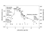
Show difficult to identify shoreline landforms of this age because they are obscured by Bonneville deposits. The Little Valley lake reached an altitude of approximately 1490 m ( 4890 ft) ( Scott et al, 1983), which is 75 to 120 m ( 250- 400 ft) lower than the Bonneville shoreline ( the highest shoreline of the Bonneville cycle, about 15,000 yr B. P.). Deposits of the Cutler Dam lake cycle are not well dated, but probably are correlative with isotope stage 4 (- 65,000 yr B. P.) or are younger (- 40,000 yr B. P.). The Cutler Dam lake reached a level of about 1340 m ( 4400 ft). The Bonneville cycle ( Lake Bonneville) is the best known of the late Pleistocene lakes; all the deposits observed by Gilbert are of this age (- 30,000- 10,000 yr B. P.). Massive shoreline deposits, erosional shorelines, deltas, and offshore sediments ( the white marl) are prominent in the Bonneville basin. Most of these can be conclusively shown to have been produced during the Bonneville lake cycle. Prominent shorelines named and mapped by Gilbert have been dated and linked to the offshore deposits, and an accurate chronology has been established that can now be used in many ways as a predictive model ( Figure 3). Despite the advances that have been made in understanding the history of Lake Bonneville and Great Salt Lake, a number of important questions remain unanswered or partially answered. These include questions about the timing and duration of the regression from the Provo shoreline and of the Provo shoreline itself, the timing and character of the initial rise of Lake Bonneville after 30,000 yr B. P., the chronology of fluctuations of Great Salt Lake during the last 10,000 yr, the precise relationships between Lake Bonneville and Great Salt Lake and climate, including the relative importance of temperature and precipitation or other variables in determining lake size, and the details of pre- Bonneville lake cycles and their connections to global climate. These questions and others are being pursued in the Bonneville basin, which is serving Figure 3. Lake Bonneville chronology modified from Oviatt et as an excellent repository and al. ( 1992), Oviatt ( 1997), and Oviatt and Miller ( in press). laboratory for paleohydrologic and Elevations are adjusted for isostatic rebound. Ul, U2, and US paleoclimatic research CCurrev are transgressive- phasefluctuations ( Oviatt, 1997). i QQfA Radiocarbon ages are indicated as follows: solid circles = disseminated organic carbon; solid squares = wood or charcoal; open circles = carbonate ( shell or tufa); open triangles = basaltic ashes. * 1500 Bonneville U3 - " shoreline~~ ~ i* jfc » U2 _ Provo ° i • 0 - '• U1 • a • • • • • shoreline " Lake Gunnison o o Stansbury shoreline oo o ° • • Pilot X Valley - Gilbert shoreline. ° c -; shoreline O o oo • • - • •• * • 1 •• • • I • - • • I - 5000 £• 4800 ro radiocarbon age ( ka) |