| OCR Text |
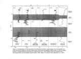
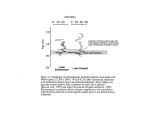
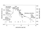
Show Lake Bonneville spilled over successively higher thresholds into those adjacent subbasins ( Currey, 1980; Currey and Oviatt, 1985; Sack, 1990). Cedar Valley was apparently also integrated by spillover from Lake Bonneville ( Currey and Oviatt, 1985). The Sevier Desert basin, on the other hand, initially drained northward over the divide into Lake Bonneville through a river channel tens of kilometers long. Lake Bonneville eventually transgressed well above that threshold, converting the connection into a strait and the tributary basin into its Sevier Desert arm. Subbasin integration by spillover from one subbasin to an adjacent one is essentially a fluvial process. Even if both basins initially contain independent closed lakes, differences in such variables as elevation, relief, hypsometry, precipitation, surface runoff, and groundwater budgets will cause the water bodies to rise at different rates ( Benson, 1978; Benson and Mifflin, 1986). The first one to overtop their connecting sill will discharge a current of water flowing downslope by the force of gravity toward the base level of the receiving basin. Depending on specific geomorphic and hydrologic conditions, this fluvial current may be intermittent or continuous, long- or short- lived, extensive or slight in length. In both the Puddle Valley and Tule Valley subbasins of Lake Bonneville, a well- exposed example of a distinctive landform created during integrating inflow is found adjacent to the subbasin threshold. Combined with the results of valley- wide investigations, a comprehensive analysis of the geomorphology, sedimentology, and morphostratigraphy of these gravel inflow bars provides insights into the nature of the subbasin integration process and the timing of Lake Bonneville's integration of the two valleys. From the composition and large size of transported clasts and the presence of giant current ripples on the linguoid bars it is inferred that in both subbasins Lake Bonneville spilled in as a high- velocity flow which was accompanied by failure of material at the threshold. The ideal linguoid form was more closely achieved in Puddle Valley than in Tule Valley because in the latter subbasin an abrupt decrease in flow velocity occurred where the inflowing current hit the water of pre- existing Lake Tule ( Sack, 1990). Both of the bars are well preserved because the subbasin water level rose rapidly over them on the transgression and fell relatively quickly past them during the regressive phase of the lake cycle. References Benson, L. V., 1978, Fluctuation in the level of pluvial Lake Lahontan during the last 40,000 years: Quaternary Res., v. 9, p. 300- 318. Benson L. V., and Mifflin, M. D., 1986, Reconnaissance bathymetry of basins occupied by Pleistocene Lake Lahontan: U. S. Geological Survey Water- Resources Investigation Report 85- 4262. Benson, L. V, and Paillet, F. L., 1989, The use of total lake- surface area as an indicator of climate change: Examples from the Lahontan basin: Quaternary Research, v. 32, p. 262- 275. Currey, D. R., 1980, Coastal geomorphology of Great Salt Lake and vicinity: Utah Geological and Mineral Survey Bulletin 116, p. 69- 82. Currey, D. R., and Oviatt, C. G., 1985, Durations, average rates, and probable causes of Lake Bonneville expansions, stillstands, and contractions during the last deep- lake cycle, 32,000 to 10,000 years ago, in Kay, P. A., and Diaz, H. F., eds., Problems of and Prospects for Predicting Great Salt Lake Levels: Salt Lake City, University of Utah Center for Public Affairs and Administration, p. 9- 24. |


