| OCR Text |
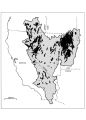
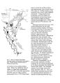
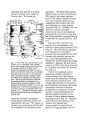
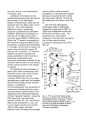
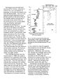
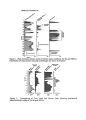
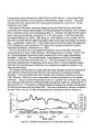
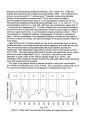
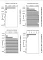
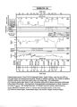
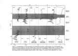
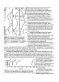
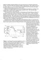
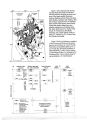
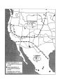
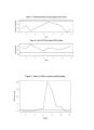
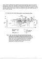
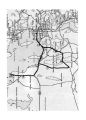
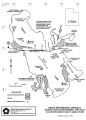
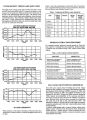
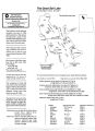
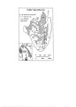
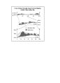
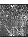
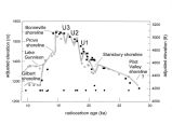
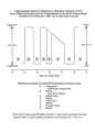
Show Reno and Carson City, would back up the Humboldt River at least to Battle Mountain, and would extend 60 km southeast from Walker Lake to Rhodes Salt Marsh. If allowances are made for local tectonics and sedimentation in the past half- million years, the lake could have filled Dixie and Fairview Valleys and inundated other flat- lying valleys whose floors are now only a few tens of meters above the 1400- m level. Such projections permit specific hypotheses to be tested. For example, Hubbs and Miller ( 1948) postulated an " early pluvial" connection between Lake Dixie and Lake Lahontan ( fig. 1) on the basis of a subspecies of Siphateles obesus ( a chub) that inhabits a present- day spring in Pleasant Valley, the northern extension of Dixie Valley. The 1400- m level of Lake Lahontan could have flooded Dixie, Fairview, and Pleasant Valleys, providing a continuous environment for the fish. An outcrop of lacustrine deposits at altitudes as high as 1384 m in eastern Fairview Valley ( east of Lake Labou, fig. 1) provides supporting evidence for such a connection ( Reheis and Morrison, 1997). EVIDENCE FOR OLD LAKES IN OTHER BASINS New discoveries in Columbus Salt Marsh ( fig. 1) indicate at least four lake cycles higher and older than the late Pleistocene shoreline ( altitude 1400 m, 4600 ft; Mifflin and Wheat, 1979) of Lake Columbus. Progressively younger shorelines at about 1452- 1457, 1435, and 1417 m ( fig. 2) are recorded by berms and beach pebbles on bedrock slopes; outcrops at two sites expose sequences of lacustrine deposits, one containing Bishop ash. Lake Rennie existed in Fish Lake Valley at about 760 ka, with a high stand at about 1460 m ( 4800 ft), and probably a lake also existed here at about 1 Ma ( Reheis et al., 1993). I infer that during the early and early- middle Pleistocene, Lakes Columbus and Rennie were contiguously connected. Sediments in cores taken from Clayton Valley playa ( Lake Clayton, fig. 1) consist of beds of sand, mud, gypsum, and halite and include coarse tephra layers and glass- rich intervals; one thick ash bed is identified as the Bishop ash ( A. Sarna- Wojcicki, 1992, written commun.). The mud is interpreted to reflect deeper, fresh- water conditions in the lake, including one at about 760 ka ( fig. 2), and the salt beds to reflect periods of saline water and desiccation ( Davis, 1981). The late Pleistocene history and shoreline altitudes of pluvial Lake Russell ( figs. 1 and 2; present- day Mono Lake) are well known ( summarized in Benson et al., 1990). Miller and Smith ( 1981) used fossil and modern fish populations to show that fish had migrated southward into the Mono basin from the Lahontan basin, probably during the Pliocene, and later migrated southward into Owens Valley and Death Valley. Recent discoveries of an abandoned sill and beach deposits around the east side of the Mono basin suggest that Lake Russell reached an altitude between 2237 and 2277 m and drained north toward the East Walker River at least once during the late Pliocene and early Pleistocene ( figs. 1 and 2). The additional input of water from the Mono basin, if confined to the Walker Lake basin, might help to account for the early Pleistocene highstands that exceeded the late Pleistocene highstand. Late Miocene to late Pliocene lacustrine deposits ( based on tephra correlations and diatoms; Reheis and Morrison, in press) crop out in and between several basins southeast of Walker Lake ( fig. 1). They are preserved in several places in Soda Springs Valley and constitute a thick sequence of lake sediment underlying Redlich Summit, the present- day divide between Rhodes and Columbus Salt Marshes. In Fish Lake Valley, pluvial Lake Rennie had at least two late Pliocene lake cycles ( Reheis et aL, 1993). Exposures on the east side of Clayton Valley indicate at least two Pliocene lake cycles ( Davis, 1981), and recent analyses of tephra from the lower |