| OCR Text |
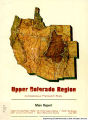
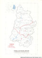
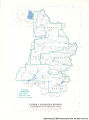
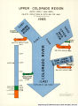
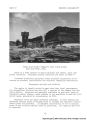
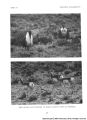
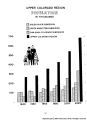
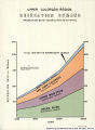
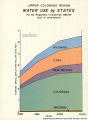
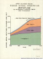
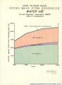
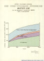
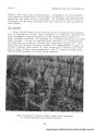
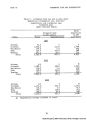
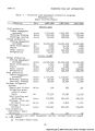
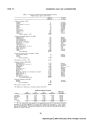
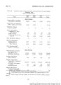
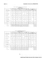
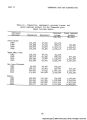
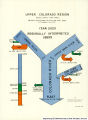
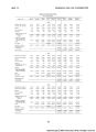
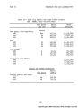
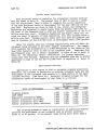
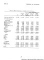
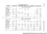
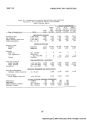
Show PART VII COMPARISONS AND CONCLUSIONS Five levels of development are defined and evaluated in this study, i.e.: Present (1965) level. Regionally interpreted OBERS. States' alternative - 6.55niillion acre-feet. States' alternative - 8.16 million acre-feet. States' alternative - water supply available at site - 9.44 million acre-feet. The framework plan, based upon the regionally interpreted OBERS pro- jection, was developed first and was used as the basis and cornerstone for other studies. Three "states' alternatives" or choices were devel- oped to reflect capability of the region to supply goods and services not fully evaluated in the OBERS projections. The 1968 OBERS and the on- going programs were also studied and will be discussed. The effect of the various levels of development on water and related land resources and economic and agricultural activity, as well as conclu- sions reached, are presented in this section. Comparisons Water supply Average annual historical discharge at the principal measuring point for the Colorado River, at Lee Ferry, Arizona, averaged 12,426,000 acre- feet for the 52-year period, 19l4 through 19&5* Because of variations in precipitation and other climatic influences, the extremes were 21,894,000 acre-feet in 1917 and 4,396,000 acre-feet in 1934. For the same period, average annual virgin or undepleted flow, as it would have been without man's influences, would have averaged 14,870,000 acre-feet. The future outflow at Lee Ferry will depend on which level of devel- opment actually occurs, as well as augmentation. Augmentation practices considered as possibilities include water-yield improvement and weather modification which may increase the supply by about 1 to 2 million acre- feet. Augmentation will definitely be required by 2020 for the two highest levels of depletion to meet Colorado River Compact apportionment to the lower basin. Local shortages in the region may occur at any level of development. 9k |