| Title |
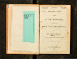
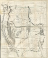
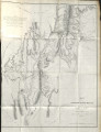
Geographical memoir upon upper California : in illustration of his map of Oregon and California |
| Call Number |
F864 .F85 1848; Record ID 9914363620102001 |
| Date |
1848 |
| Description |
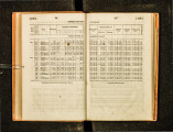
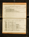
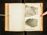
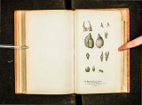
First edition. Howes, U.S.-iana, F366. Copy 2 in Rare Books is bound with: Report of the Secretary of War, communicating, in answer to a resolution of the Senate, a report and map of the examination of New Mexico made by Lieutenant J. W. Abert, of the Topographical Corps. |
| Creator |
Frémont, John Charles, 1813-1890 |
| Publisher |
Digitized by J. Willard Marriott Library, University of Utah |
| Subject |
Indians of North America -- New Mexico; Discoveries in geography -- American; United States -- Discovery and exploration; California -- Description and travel; California -- Surveys; Indigenous peoples--North America |
| Format |
application/pdf |
| Identifier |
F864-_F85-1848.pdf |
| Language |
eng |
| Rights |
 |
| Holding Institution |
Rare Books Division, Special Collections, J. Willard Marriott Library, University of Utah |
| Scanning Technician |
Ellen Moffatt |
| Digitization Specifications |
Original scanned with Hasselblad H2D 39 megapixel digital camera and saved as 600 ppi tiffs. Display images created in Adobe Photoshop Lightroom 5 and generated in Adobe Acrobat ProX as multiple page pdf. |
| ARK |
ark:/87278/s64j2fzz |
| Setname |
uum_rbc |
| ID |
306911 |
| Reference URL |
https://collections.lib.utah.edu/ark:/87278/s64j2fzz |