| OCR Text |
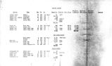
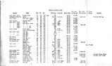
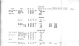
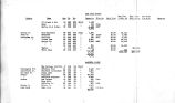
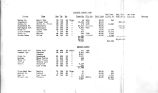
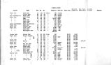
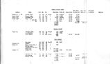
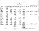
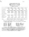
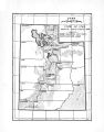
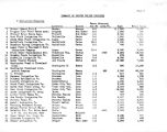
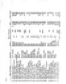
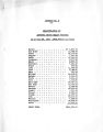
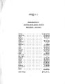
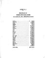
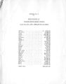
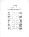
Show p To confirm the stateir* 5ni3 made above there is attached to this report as Plate I a hyarugraph of the Weber River at Oakley, Utah, showing for comparison the discharge of the river for the dry year 1931, for the normal year 1932 and for the drouth year 1934 up to May 5th and projected forward for the balance of the year. This river supplies power for the Utah Power and Light Company's Weber station, and for 102,000 acres of rich agricultural lands in Summit, Morgan, Weber and Davis counties. An inspection of this hydrograph will show that in the typical year- 1932 the river rose rapidly from 190 second- feet on April 29th to 1600 second- feet on May 22nd and reached its maximum for the year of 2200 second- feet on June 15th. In the dry year 1931 the river started to rise from 110 second- feet on April 28th ( one day earlier than 1932 and with 58% of the flow) to a maximum of 990 second- feet on Kay 17th ( 29 days earlier and with 41% of tho flow). In the drouth year 1934 the river started to rise from only 55 sfccond- fiet on April 5th ( 24 days earlier than 1932 ard with 29$ of the flow) and reached its maximum discharge of 466 second- fee- on April £ 5th ( 51 days earlier than 1932 and with 20$ of the flow). In other words the river reached its maximum discharge thie year four days earlier than it started to rise in the typical year 1932* Also note that for the year 2932 low water or summer flow commenced on July 10th with 250 second- feet. # or the dry year 1931 low water commenced on June 19th with 150 second- fest ( 22 days earlier and with 60% of the flow); and for the present drouth year it is anticipated that low wat& r will be reached by June 15th with only 70 secondrfeet of water ( 26 days earlier then 1932 and with 28% of the flow)* Computation of the acre- feet of water available for irrigation during the six months irrigation season, April to September inclusive, also emphasizes the seriousness of the situation. For the normal year 1932 this amount shows 166,060 acre- feet j for the dry year 1931 - 61,370 acre- feet; being 3?% of normal and for the drouth year 1934 and maximum anticipation of 39,000 acre- feet;, being only 23% of normal. Tuie hydrogrph was furnished by the United states Geological Survey and is summarized in the table on the attached sheet. ? rom an analysis of the run- off for all the streams in the State of Utah, prepared by Professor George V. Clyde, Irrigation - Engineer of the Utah State Agricultural College, this stream is typical of the balance of Utah streams, which will show a potential run- off of from 25% to 45% of the 1933 flow which was only 70% of normal thus reducing 1934 flows to from 17% to 31% of normal* Professor Clyde's report is attached hereto as 4pp# ndix I. |