| OCR Text |
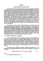
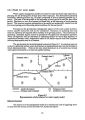
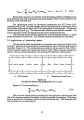
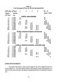
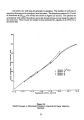
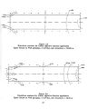
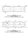
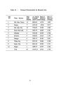
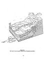
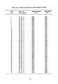
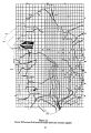
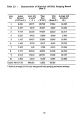
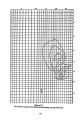
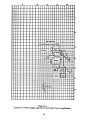
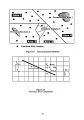
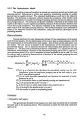
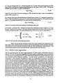
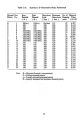
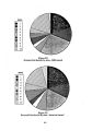
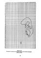
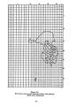
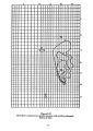
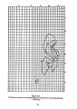
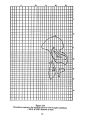
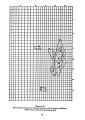
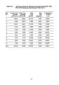
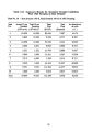
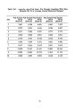
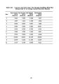
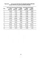
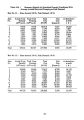
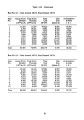
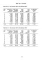
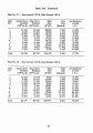
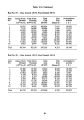
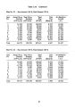
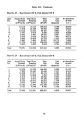
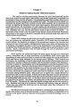
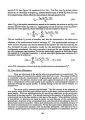
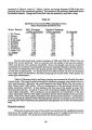
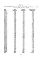
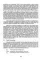
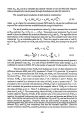
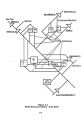
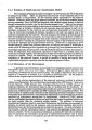
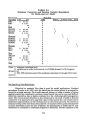
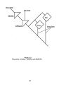
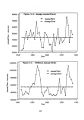
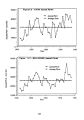
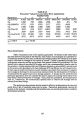
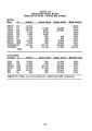
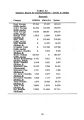
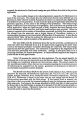
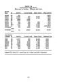
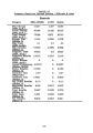
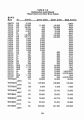
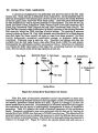
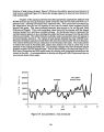
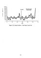
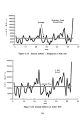
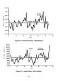
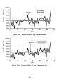
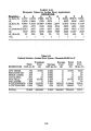
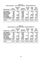
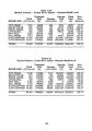
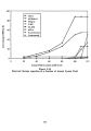
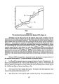
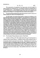
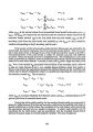
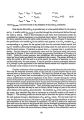
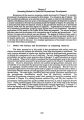
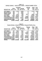
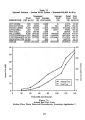
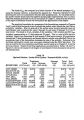
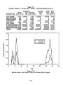
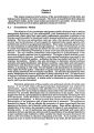
Show 5.5 Jordan River Basin Applications A second set of applications was performed with reservoir sites in the Salt Lake County area. These sites are on tributaries of the Jordan River. Seven candidate sites for reservoir development were selected upon a review of over 30 sites in the county reviewed in the Salt Lake County Area- wide Water Study ( 1982). These sites were selected based on data availability as well as reported potential for development. The sites are on City Creek, Red Butte Creek, Emigration Creek, Parleys Creek ( Little Dell reservoir), Mill Creek, Big Cottonwood Creek ( Argenta site) and Little Cottonwood Creek ( Site D). The Little Dell site ( currently under construction) is directly upstream of the existing Mountain Dell reservoir, which has 3200 Acre- feet of active storage. The resulting 8 reservoir system is shown in Figure 5.8. Only M& I demands were considered for a single demand area ( Salt Lake City owns virtually all rights to water from these streams). No flood control, hydropower, recreation, conservation storage, or irrigation yields were considered. Treatment costs at each site vary. Treatment and storage cost data was available from the Salt Lake County Area- wide Water Study ( 1982) for each stream. Consequently the optimization problem was posed as follows. Determine the minimum cost solution for M& I water supply to Salt Lake City, considering treatment and storage costs, firm ( no failure) yields and storage capacities at each site. City Creek Red Butte Creek L. Dell Creek Mill Creek B. Cottonvood Diver. i _ •. Lambs Cr Creek Lambs Cr 1 L. Dell Mt. Dell L. Cottonvood Creek Jordan River Figure 5.8 Jordan River Basin Reservoir System Fifty five years of concurrent streamflow record was available at these sites. Preliminary statistical analysis indicated a very high degree (> 0.96) of correlation between the monthly streamflow records across all 8 sites. Figures 5.9 through 5.16 show the annual streamflows at these sites. An examination of the annual streamflow data supports the conclusion that the region is hydrologically homogeneous in terms of streamflow generation. Table 5.10 presents the values of selected parameters of the optimization model. Parametric optimization runs were performed with this data set by varying the demand level from 20,000 Acre- feet/ year to 120,000 Acre- feet/ year. The objective of the parametric applications was to evaluate the sequence in which the different reservoir sites enter the solution as demands increase. The results from these applications are presented in. Tables 5.11 through 5.17. Figure 5.17 shows the optimal annual and unit costs as a 140 |