| OCR Text |
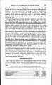
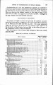
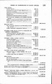
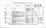
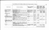
Show REPORT OF COM&TISSIONEB OF INDIAN A F F F , 117 and the work of the town-site commission closed. The following' amounts were received: Pawhuska town site .............................................. $3,902.76 o r e to wn t e 622.00 B i g ow n s i t. . 810.25 Homlny town site------------------------------------------------ 4,345.50 Fairfax town site------------------------------------------------ 6,605.50 18,846.00 027 and gm.-Only a few subleases or assignments of interest, cov-ering oil and gas lands within the 680,000 acres embraced in the Foster oil and gas lease, have been submitted to the office during the last fiscal year. Practically the whole of this field is now in the hands of actual operators, and the development of petroleum and natural gas has been going on steadily throughout the year. During the year ended December 31, 1907, the total quantity of crude petroleum run from the Osage Reservation to the Prairie Oil and Gas Company was 5,085932.49 barrels; to the Uncle Sam Oil Company 56,757.92 barrels; to the Superior Refining Company 2,002.56 barrels; 5,143,870.97 barrels in all. Under the act extending the Foster lease, the royalty to be paid the Indians is one-eighth of all the oil produced, amounting to 642,983.87 barrels. A mnservative estimate places the production of natural gas, under present development, at about 350,000,000 cubic feet per day. This does not include the gas known as " casing head gas," produced from certain wells classed as combination wells, which is used by many of the operators for fuel, lighting and other purposes. WARM SPRINGS RESERVATION BOUNDARY. In an opinion rendered May 24, 1906, the Assistant Attorney-Gen-eral for the Interior Department held that the true northern line of the Warm Springs Reservation in Oregon, defined by the treaty of June 25, 1855 (12 Stat. L., 963), was correctly run by Handley in 1871, from the initial point established by him "up to and including' the 26th mile thereof," and that Congress bad so declared by the act of June 6,1894 (28 Stat. L., 86) ; that the true line for the remainder of the northern boundary was declared by that act to be "thence in a due west course to the summit of the Cascade Mountains," as found by the commissioners who were appointed under the Indian appro-priation act of August 19, 1890 (26 Stat. L., 33&355), and who re-ported to the department June 8,1891; and that from this point the true westerly boundary must begin and run, as the treaty provides, " southerly to Mount Jefferson." As section 2115 of the Revised Statutes of the United Staten pro-rides for the survey of the boundaries of Indian reservations under |