| OCR Text |
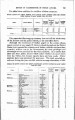
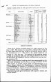
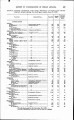
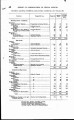
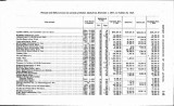
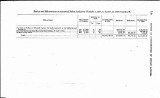
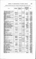
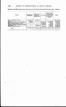
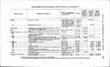
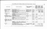
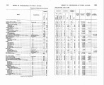
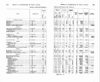
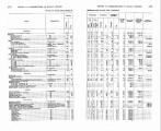
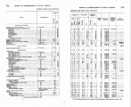
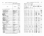
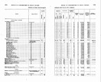
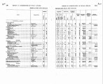
Show REPORT OF COMMISSIONER OF INDIAN AFFAIRS. 7% RAILROADS ACROSS INDIAN LANDS. Railroad construct?en across Indian lands is particularly active in the Northwest, arid several important lines have been completed or are in course of construction. All grants of rights of way to railroad companies through Indian lands, except in Oklahoma, are made in accordance with the provisions of the act of March 2, 1899 (30 Stat. L., 990), as amended by the act of June 21.,19 06 (34 Stat. L., 325). RAILROADS OUTSIDE OF OKLAHOMA The following is a summary of railroad construction affecting Iu-dian lands outside of Oklahoma, for the year ended June 30, 1908: Ariaom and California.-The map of definite looation of this com-pany over the Colorado River Reservation, and a map showing the amended location of its line were approved'on May 12 and Novem-ber 24, 1906, respectively. Station' grounds consisting of 40 acres were acquired at Parker, Ariz., under the act of March 16,1908 (35 Stat. L., 43), and the map showing them was approved on June 10, 1908. Action has been taken by the office to obtain adequate compen-sation for the land acquired. Chicago, Milwaukee and St. Paul.-On August 28, 1907, the de-partment approved a schedule showing damages caused by this com-pany's location of 6 station grounds, covering 82.16 acres, in the Standing Rock Reservation in North and South Dakota, amounting to $1,232.40, which has been paid. This company was granted on October 15, 1907, 11.4 acres for station-ground purposes in the Cceur d'Alene Reservation in Idaho. Damages in the sum of $114 have been assessed and paid. I Permission, in the nature of a license, was granted the company by the department on October 23, 1907, subject to the provisions of the act of February 15, 1901 (31 Stat. L., 790), to cross a part of the &ur~d7Alene Resernti?n with a pipe line for water supply pur-poses. A map showing amended right of way for a distance of 13.84 miles was approved on December 10, 1907. Denver, Northwestern and Paci$c.-Maps of definite location wore approved on August IT1907,, showing right of way over the Uintah ' Reservation in Utah for a distance of 95.134 miles. These maps were approved subject to the right of the united States to. crbss the right of way and the works constructed thereon with any canals or water conduits of any kind, or telephone or electric transmission lines, which may be built by the United States, or to flood all lands in the Strawberry Valley below the eleva6on of 7,538 feet above the United States Geological Survey datum, the United States to be released from all damages 'multing from such construction. 6326SG9-6 |