| OCR Text |
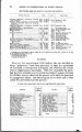
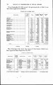
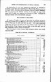
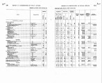
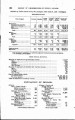
Show I REPORT OR ~ ~ ~ ' ~ ~ ' ~ I S S IOOF NINEDRIA N A F B ~ S . 89 WHITE EARTH TOWN SITE. The act of March 1, 1907 (84 Stat. L., 1015-1032), authorized the Secretary of the Interior, with the consent of the Indians, to set apart the SW. t of the SW. a, the E. g of the SW. 4, and the W. g of the SE. 2 of sec. 28, T. 142, R. 41, as a town site, to cause the land to be surveyed in6 suitable lots, blocks, streets and alleys, and to dispose of the lots. The town-site board consisted of Charles G. Sturtevant, John Leecy and the superintendent in charge of the White Earth Agency. The original plat of survey, scheduie of appraissment of lots and schedule of lots containing permanent improvements were approved on December 12,1907. The lots containing permanent im-provements were appraised at $1,742, and were sold to the owners thereof at the appraised value. At an auction sale of lots containing no improvements, held on March 10, 1908, 14 lots were sold at an aggregate price of $445. The schedules of both sales were approved on May 8. During &fay, the attention of the department was invited to the fact that the town-site board had reserved only lots 10 and 11 in block 3 for schoolhouse purposes, instead of one square " as required by the act, and on May 27, the department directed that the board be instructed to reserve one entire block for schoolhouse purposes. On July 6, the board submitted an amended plat of survey of original block 2, showing its subdivision into two blocks, one of which was designated block 17, and marked '' reserved for schoolhouse purposes." This amended plat was approved on 'August 3. BOUNDARY OF TONGUE RIVER RESERVATION. .On recommendation of this o5ce the Commissioner of the General Land O5ce was instructed to determine by proper survey the main stream of Cook Creek in Montana, which forms a part of the bound-ary of the Tongue River or Northern Cheyenne Reservation in that State. A contract for the survey was executed, and I am informally advised by the General Land O5ce that the surveys have been com-pleted in the field, but that the plats have not yet been transmitted by the surveyor-general of Montana for acceptance. The location of Cook Creek by this survey will fix the boundary of that part of the reservation and end the disputes over it. BY-A-LIZ-LE AND HIS NAVAHO CONFEDERATXlS. On March 29, 1907, the superintendent of the San Juan school at Shiprock, N. Mex., reported that on several occasions a settlement of renegade outlaw Indians on the south side of the San Juan River in Utah, some 40 miles north of Shiprock, had defied the authority of |