| Title |
Annual Report of the Commissioner of Indian Affairs - 1904 (Pt I) |
| Subject |
Indian reservations; Federal government; Indians of North America; Maps; Work; Land use; Allotment of land; Treaties; Agriculture; Timber; Health; Indians of North America--Social life and customs; Water rights; Natural resources; Railroads; Education; Indians of North America--Education; Irrigation; Intermarriage; Culture; Employment (Economic theory); Annuities; Indigenous peoples--North America |
| Keywords |
Annual Report; Indian Agency; Reservations; Land Rights; Allotment; Resources; Tribal Funds; Native Americans |
| Publisher |
Digitized by J. Willard Marriott Library, University of Utah |
| Tribe |
Ute |
| Language |
eng |
| Description |
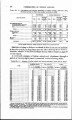
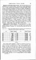
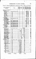
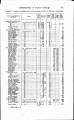
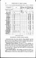
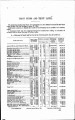
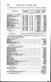
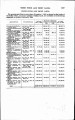
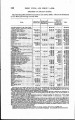
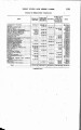
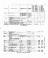
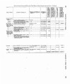
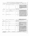
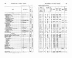
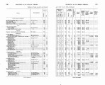
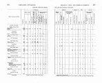
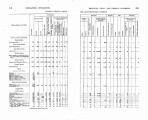
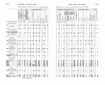
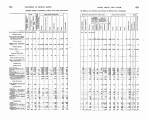
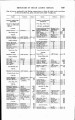
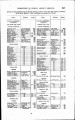
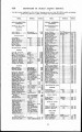
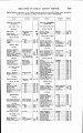
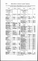
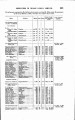
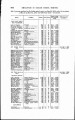
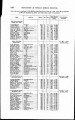
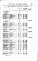
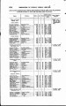
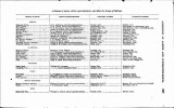
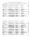
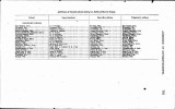
Excerpts concerning Utah from the Annual Report of the Commissioner of Indian Affairs - Courtesy of the University of Wisconsin Digital Collections. The Commissioner of Indian Affairs discusses the distribution of allotments (including those on the Uintah Reservation) and the leasing of un-alloted land and makes recommendations regarding irrigation of Indian lands. The Commissioner also describes costs, enrollment, and success pertaining to Indian schools and the protocol for preventing the spread of communicable diseases. Captain Hall of the Uintah Ouray Reservation submits a report in which he provides census data and a summary of wages and rations, and describes the condition of the reservation schools. The Superintendent of the Uintah School provides a report regarding enrollment, health, and the curriculum of the school. The Superintendent of the Ouray School describes conditions on the school grounds |
| Type |
Text |
| Coverage |
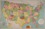
Uintah and Ouray Indian Reservation (Utah); Utah; Washington (D.C.) |
| Format |
application/pdf |
| Rights |
Digital Image © 2011 America West Center. All Rights Reserved |
| ARK |
ark:/87278/s6xh2mvg |
| Creator |
Commissioner of Indian Affairs |
| Date |
1904 |
| Spatial Coverage |
Uintah and Ouray Indian Reservation (Utah); Washington (D.C.); Utah |
| Setname |
uaida_main |
| ID |
374540 |
| Reference URL |
https://collections.lib.utah.edu/ark:/87278/s6xh2mvg |