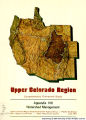
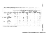
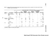
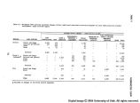
| Title |
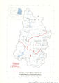
Upper Colorado Region Comprehensive Framework Study: Appendix VIII, Watershed Management |
| Creator |
Upper Colorado Region State-Federal Interagency Group for the Pacific Southwest Interagency Committee Water Resources Council |
| Subject |
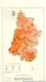
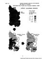
Watershed management; Erosion; Flood damage |
| Publisher |
Upper Colorado Region State-Federal Inter-agency Group : Pacific Southwest Inter-agency Committee, Water Resources Council |
| Contributors |
Case, Fred O.; Accola, Robert C. |
| Date |
1971-06 |
| Type |
Text |
| Format |
application/pdf |
| Language |
eng |
| Rights Management |
Digital image copyright 2004, University of Utah. All rights reserved. |
| Contributing Institution |
S.J. Quinney Law Library, University of Utah. 332 South 1400 East, Salt Lake City, UT 84112-0730 |
| Source Physical Dimensions |
26cm x 20cm |
| Scanning Technician |
Backstage Library Works 1180 S. 800 E. Orem, UT 84097 |
| Call Number |
KF5582.C6 A8 App. VIII |
| ARK |
ark:/87278/s6fq9vz3 |
| Setname |
wwdl_documents |
| ID |
1133270 |
| Reference URL |
https://collections.lib.utah.edu/ark:/87278/s6fq9vz3 |