| OCR Text |
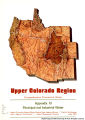
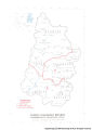
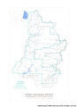
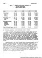
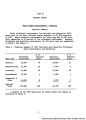
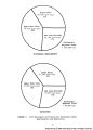
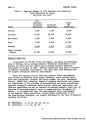
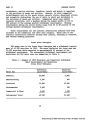
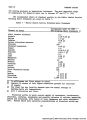
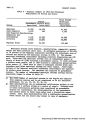
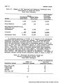
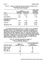
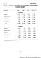
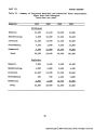
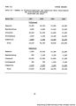
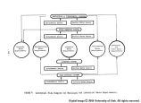
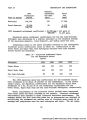
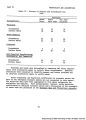
Show PART I INTRODUCTION Projected growth and Increased industrial development requires addi- tional lands. Thus, encroachment upon other land-use areas occurs. In most instances, encroachment is made upon agricultural land areas, which reduces at-site agricultural production and agricultural water require- ments with a corresponding increase in the water supply available for municipal and industrial water uses. Encroachment on land-use areas is discussed in the Land Resources and Use Appendix. Description of the Region The study area is the Upper Colorado Region which comprises the drainage basin of the Colorado River above Lee Ferry, Arizona, and the Great Divide Basin in southcentral Wyoming. The Region includes parts of Arizona, Colorado, New Mexico, Utah and Wyoming. It encompasses an area of 113,496 square miles, including 109,580 square miles in the Upper Colorado River drainage and 3,916 square miles in the Great Divide Basin. The Region is bounded on the east and north by mountains forming the Continental Divide and on the west by the Wasatch Mountains. On the south it opens to the Lower Colorado Region at Lee Ferry in northern Arizona. The study area has been divided into three hydrologic subregions comprising the natural drainage basins of the Colorado River and its two principal tributaries, the Green and San Juan Rivers. The Region is sparsely populated. The population was about 336,000 in 1965. The average density was about three persons per square mile compared with a national average of 64. Forty-one percent of the popula- tion resided in the Upper Main stem subreglon, 30 percent in the Green River subregion and 29 percent in the San Juan-Colorado subregion. The 1965 and projected population are presented in Table 1. |