OCR Text |
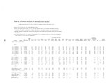
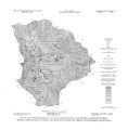
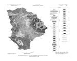
Show substantially more chloride than sulfate. One sample was very high in iron ( 34 mg/ l), but this seems to be a local condition; the few other analyses indicate little or no iron in solution. Water from the hot pots is a calcium sulfate bicarbonate type ( diagram 4, fig. 9), and is by far the most mineralized water in the area. Concentrations of dissolved solids in 10 samples of the thermal water ranged from 1,650 to 2,160 mg/ l, and total hardness ranged from 960 to 1,270 mg/ l. The water is saturated with respect to calcium carbonate at normal temperatures and pressures; calcium carbonate precipitates from samples that are allowed to stand for a few days exposed to the atmosphere. Ground water in the unconsolidated deposits The principal source of water to wells in the Heber- Kamas- Park City area is the unconsolidated alluvial fill in the major valleys. Unconsolidated deposits in the mountains have little significance as aquifers. The stratigraphy, lithology, and water- bearing characteristics of the unconsolidated deposits are summarized in table 2. The areal distribution of the various units is shown on plate 2. Table 2.- Generalized description of the unconsolidated deposits in the Heber- Kamas- Park City area Age Unit Lithology and thickness Water- bearing properties Younger alluvium Poorly sorted mixture of material ranging in size from clay to boulders. All beds appear to be lenticular and discontinuous. Thickness ranges from 0 to about 1,000 feet. Underlies the valley floors of Heber Valley, Rhodes Valley, Parleys Park, and Round Valley and forms low terraces along the margins of Heber and Rhodes Valleys. The two units cannot be distinguished lithologically; the terraces are mapped as older alluvium and the valley floors as younger alluvium, but older alluvium probably also underlies the valley floors. These deposits form the best and most productive aquifers in the study area. Water- table conditions predominate. Hydraulic conductivity ranges from 20 to 50 ft^/ d/ ft , estimated specific yield ranges from 12 to 15 percent. Most aternary Older alluvium wells and many springs in the study area yield water from these deposits. o- Landslide deposits Unsorted material ranging from clay through boulders. Thickness unknown. Present only in a few isolated areas of the mountains. Hydrologic properties unknown, but the scattered small deposits have no hydrologic significance in the area. Glacial deposits Includes outwash deposits, morainal deposits, and glacially striated bare ground. Present in the higher elevations of both the Wasatch Range and the Uinta Mountains. The small areas of sorted outwash undoubtedly store and transmit some ground water, but the glacial deposits as a whole have no significance as aquifers in the study area. 8 Older high- level gravel surfaces of uncertain age Planed surfaces underlain by thin deposits of gravel. Thickness uncertain. Present only in southeastern part of study area. No data concerning hydrologic characteristics, but not significant as an aquifer in the study area. Heber Valley Heber Valley, on the Provo River, is the largest of the four valleys included in the study area ( pi. 1 and fig. 1). The valley floor is roughly triangular in plan and has an area of about 44 square miles. The Provo River enters the valley at the northern apex of the triangle and flows out near the southwestern apex. Three small tributaries of the Provo River- Lake, Center, and Daniels Creeks- enter the valley near the southeastern apex, and a fourth tributary, Snake Creek, enters about midway on the western side of the valley. The valley floor is thickly blanketed with unconsolidated debris, and each of the tributary streams has built a substantial alluvial fan at the mouth of its canyon. Two wells in Heber Valley that pass through the entire thickness of unconsolidated material reached consolidated rocks at depths of about 310 feet. Geophysical studies, however, 25 |